Catalog Archive
Auction 147, Lot 346

"[Lot of 2] A Plan of Lima [and] A Plan of the Town of Payta in the Kingdom of Santa-Fee",

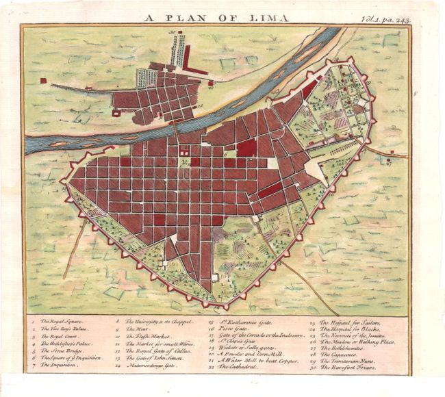
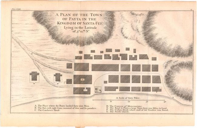
Subject: Lima & Paita, Peru

Period: 1745 (circa)

Publication:

Color:

Size:
See Description
Download High Resolution Image
(or just click on image to launch the Zoom viewer)

A. A Plan of Lima, by John Harris, from Navigantium, hand color (8.5 x 7.7"). A lovely bird's-eye plan of the city of Lima with a numbered key at bottom identifying 30 locations on the map. This sheet was published with a view of Potosi at bottom, which has been removed from this example. Reference: Shirley (BL Atlases) G.HARR-1a #5.1. Condition: On watermarked paper that has been remargined at bottom. There are a few short tears in the blank margins, most of which have been closed with archival tape on verso.

B. A Plan of the Town of Payta in the Kingdom of Santa-Fee, by George Anson, from A Voyage Round the World..., black & white (15 x 8.6"). This plan is based on Anson's sack of Paita in November of 1741. A lettered key at the bottom notes important locations such as The Convent of Mercenarians and The Custom-House, where most of the Treasure was found. Reference: cf. Shirley (BL Atlases) G.ANS-1a #6. Condition: Issued folding on watermarked paper with minor toning and faint offsetting.

References:

Condition: B+

See description above.

Estimate: $180 - $210

Sold for: $90

Closed on 11/20/2013

Archived