Catalog Archive
Auction 146, Lot 652

"Chorographia Terrae Sanctae in Angustiorem Formam Redacta, et ex Variis Auctoribus a Multis Erroribus Expurgata", Tirinus, Jacobus
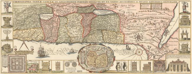
Subject: Holy Land

Period: 1700 (circa)

Publication:

Color: Hand Color

Size:
32.4 x 12.6 inches
82.3 x 32 cm
Download High Resolution Image
(or just click on image to launch the Zoom viewer)

Panels illustrating sacred objects surround this stunning map of the Holy Land. Oriented with east at top, the map includes the territories of the twelve tribes on both sides of the Jordan River and the route of the Exodus and Wandering. At center is an inset bird's-eye plan of ancient Jerusalem based on the Spanish biblical geographer, Juan Bautista Villalpando. The decorative panels include a menorah, the arc of the covenant, the altar of sacrifices, the Tabernacle, and a plan and elevations of the Temple. Two sheets joined as issued.

References: Laor #771.

Condition: A

Issued folding on watermarked paper with a few small worm holes and chips in far blank margins that have been archivally repaired.

Estimate: $1,000 - $1,300

Sold for: $700

Closed on 9/4/2013

Archived