Catalog Archive
Auction 146, Lot 319

"St. Vincent, from an Actual Survey Made in the Year 1773. After the Treaty with the Caribs", Jefferys/Sayer

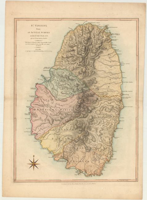
Subject: St. Vincent

Period: 1775 (dated)

Publication: The West Indian Atlas

Color: Hand Color

Size:
18.3 x 24.3 inches
46.5 x 61.7 cm
Download High Resolution Image
(or just click on image to launch the Zoom viewer)

Thomas Jefferys was one of the most important English map publishers of the 18th century. His work included prints and maps of locations around the world, but his most notable maps are of North America and the West Indies. He began his career in the map trade in the early 1730s, working as an engraver for a variety of London publishers, and eventually setting up his own shop. In 1746, he was appointed Geographer to the Prince of Wales, and in 1760 he became Geographer to the King. These titles granted access to manuscripts and cartographic information held by the government. In the early 1760s he embarked on an ambitious project to produce a series of English county maps based on new surveys, but ran out of money and filed for bankruptcy in 1766. He then partnered with London publisher Robert Sayer, who reissued many of Jefferys plates and continued to issue new editions after Jefferys' death in 1771. Jefferys' American Atlas and the accompanying West-India Atlas, published post posthumously, are considered his most important cartographic works.

The treaty to which the title refers was short-lived and it was not until 1797 that Carib resistance was finally crushed. The island was an important part of the British presence in the Caribbean due to sugar production. A note below the title explains, "This Island of St. Vincent is 18 miles 1/8 long, and 11 miles 1/5 broad, has 22 rivers capable of turning sugar mills, and contains 84,286 acres." The map illustrates the important rivers and shows the four parishes. The northern part of the island is noted as Caribs Lands where the Morne a Garou mountains dominate the topography. This is the first edition, and one of the earliest obtainable maps of St. Vincent.

References: Tooley (MCC-81) #5; Shirley (BL Atlases) M.JEF-4a #34.

Condition: A

A nice impression on heavy, watermarked paper with a hint of offsetting.

Estimate: $500 - $650

Sold for: $275

Closed on 9/4/2013

Archived