Catalog Archive
Auction 146, Lot 25

"Nova Totius Terrarum Orbis Tabula Amstelodami per I. Danckerts cum Privil.", Danckerts, Justus
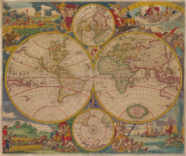
Subject: World

Period: 1685 (circa)

Publication:

Color: Hand Color

Size:
23 x 19.3 inches
58.4 x 49 cm
Download High Resolution Image
(or just click on image to launch the Zoom viewer)

This is Danckerts' version of De Wit's splendid maritime world map. The cartographic features include the island of California and an open-ended Great Lakes on the Sanson model in North America. A remnant of Lake Parime is still shown in South America. In Africa, the Nile still rises from twin lakes and the interior is mostly guesswork. In Asia, Australia is represented only by the northern and western coastlines and Van Diemen's discoveries are shown in Tasmania and New Zealand. Above and below the map are polar projections. Lively allegorical scenes representing the four elements surround the map. Fire is depicted by a fierce battle scene and the abduction of Persephone; air as the heavenly realm ruled by Zeus and Hera; water by Neptune with his entourage, sailing ships and a fantastic spouting whale; and earth by Demeter and two other earth goddesses in a peaceful scene of harvesting and husbandry. This is Danckerts' second of two similar maps, with geography updated from De Wit's original. In the Antarctic sphere, all of the southern continents are depicted as far as the equator, whereas previously only the tip of South America was shown. In addition, Nova Guinea appears in the western hemisphere and the northwest coast of North America is illustrated and named Terra Esonis.

References: Shirley #529.

Condition: B

Light toning and backed in tissue with professional repairs to several centerfold separations, a long horizontal tear north of the equator that spans two-thirds of the sheet, a tear that enters 4" into image at top, and a few other small chips and tears, with a small amount of image in facsimile.

Estimate: $4,000 - $4,750

Sold for: $2,500

Closed on 9/4/2013

Archived