Catalog Archive
Auction 146, Lot 198

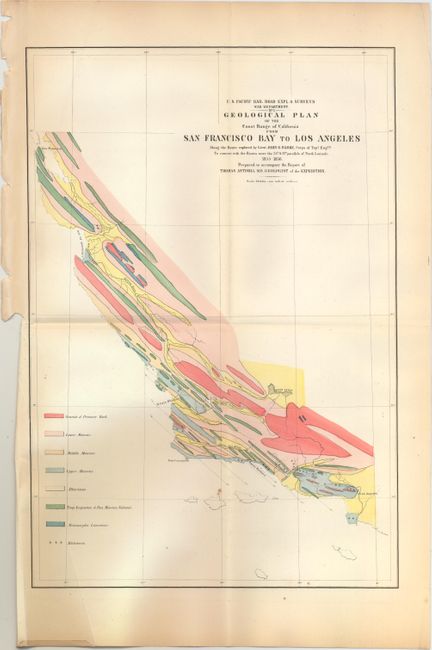
"Geological Plan of the Coast Range of California from San Francisco Bay to Los Angeles…", U.S. War Department

Subject: California

Period: 1855-56 (dated)

Publication:

Color: Hand Color

Size:
11.4 x 16.8 inches
29 x 42.7 cm
Download High Resolution Image
(or just click on image to launch the Zoom viewer)

During the 1850s, the U.S. government sponsored an extensive series of expeditions designed to gather information on the vast new territories that had been acquired in western North America. The discovery of gold in California further stimulated westward traffic and heightened the need for a faster and more convenient way to bring the far-flung parts of the country together. In 1853 Congress commissioned the Army's Topographic Bureau to conduct a series of surveys to find a suitable route for a transcontinental railroad. There were six major expeditions; five of them covered the area between the Great Plains and west coast, and the sixth explored the coastal states of California and Oregon. All of these expeditions were accompanied by naturalists and artists to document the landscape, flora and fauna along the route. The reports, maps and lithographs were published in the 13 volume report "Explorations and Surveys to ascertain the most practicable and economical route for a Railroad from the Mississippi river to the Pacific Ocean."

This colorful map details the coast and coastal mountain range between San Francisco and Los Angeles. Names Point Conception, Santa Barbara, the Bay of Monterey, and the major rivers in the region and extends eastward to include the Kern Lakes. The legend at lower left identifies eight geological formations with a color key.

References:

Condition: B+

Issued folding with a few tiny spots, light toning at left, one tiny edge tear at left that just passes the neatline and an extraneous crease at bottom left.

Estimate: $150 - $200

Sold for: $110

Closed on 9/4/2013

Archived