Catalog Archive
Auction 146, Lot 16

Rare Second Plate of Ortelius' World Map

"Typus Orbis Terrarum", Ortelius, Abraham
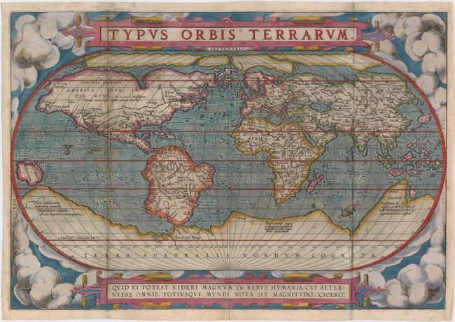
Subject: World

Period: 1587 (circa)

Publication: Theatrum Orbis Terrarum

Color: Hand Color

Size:
18.9 x 12.8 inches
48 x 32.5 cm
Download High Resolution Image
(or just click on image to launch the Zoom viewer)

This is the second (of three) world maps that were included in Ortelius' famous atlas. It is a simplified reduction of Mercator's influential map of 1569 presented on an oval projection rather than the projection for which Mercator is now famous. From surviving correspondence, it is known that Mercator encouraged Ortelius and provided him with information, particularly with coordinates of places in the Americas. Placed on a cloud background, the map shows North America as much too wide and South America retains the unusual bulged southwestern coastline. At the poles, a prominent Northwest Passage snakes its way south of the four islands making up the arctic regions, and a huge Terra Australis Nondum Cognita makes up the imaginary southern continent. A notation next to New Guinea notes that it is unknown if this large island is a part of the southern continent. The title is in a strapwork banner at top, which is balanced with a quotation from Cicero at bottom. This superb map was engraved by Frans Hogenberg, although his imprint does not appear on this plate. This plate is very rare and was only used for 4 editions of the Theatrum between 1587-98, with an estimated 750 copies printed. This is the second state of the plate with the date removed. The verso is blank, indicating that this map was likely derived from a composite atlas.

References: Shirley #122; Van den Broecke #2.2.

Condition: B

Issued folding, now pressed on watermarked paper with attractive old color that has been partially refreshed. There is light soiling and professional repairs to several fold separations and to a 2.25" tear in Canada.

Estimate: $7,000 - $9,000

Sold for: $4,750

Closed on 9/4/2013

Archived