Catalog Archive
Auction 146, Lot 121

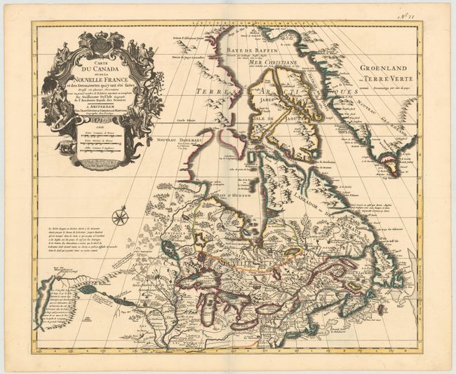
One of the most influential maps of Canada, the Great Lakes and Upper Midwest

"Carte du Canada ou de la Nouvelle France et des Decouvertes quiy ont ete Faites...", Delisle/Covens & Mortier

Subject: Colonial United States & Canada

Period: 1730 (circa)

Publication:

Color: Hand Color

Size:
22.6 x 19.3 inches
57.4 x 49 cm
Download High Resolution Image
(or just click on image to launch the Zoom viewer)

First issued in 1703, this richly detailed map provides the most accurate rendering of the Great Lakes of the time, with the lakes fully enclosed and properly placed in longitude and latitude. Delisle's map of Canada and the Great Lakes is one of the most outstanding and influential maps of the eighteenth century. Detroit marks its debut on this map, only two years after its founding. Delisle's cartography is very meticulous and adds new information from Joliet, Franquelin, and the Jesuit explorers. It correctly positions the Ohio River but confuses its name with the Wabash River. West of the Mississippi Lahontan's fictitious Riviere Longue is prominently depicted. In Canada special attention is given to the rivers and lakes between Hudson Bay and the St. Lawrence, and Lac de Assenipoils (Lake Winnipeg) connects to Hudson Bay. Sanson's three islands of the Arctic are retained. The exquisite cartouche with a beaver, natives, priest and friars, was engraved by Guerard. This is the second state of the map and remains essentially unchanged from the first edition.

References: Kershaw #318; Tooley (Amer) p. 20 #39.

Condition: A+

A fine, dark impression with original color and good margins. There are two tiny tears in left blank margin, far from map, that have been closed on verso with archival tape.

Estimate: $1,400 - $1,700

Sold for: $1,300

Closed on 9/4/2013

Archived