Catalog Archive
Auction 145, Lot 115

"[Lot of 2] Carte Generale des Decouvertes de l'Amiral de Fonte … [and] Carte des Parties Nord et Est de l'Asie qui Comprend Les Cotes de La Russie Asiatique le Kamschatka, Le Jesso, et Les Isles Du Japan", Robert de Vaugondy, Didier

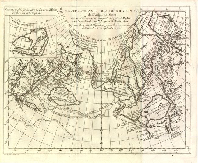
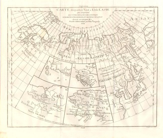
Subject: Western North America, Asia

Period: 1752-72 (circa)

Publication: Diderot's Encyclopedie

Color: Black & White

Size:
See Description
Download High Resolution Image
(or just click on image to launch the Zoom viewer)

When Charles Joseph Panckoucke took over publication of Diderot's Encyclopedie in 1768, he promised to correct the cursory treatment of geography for which the first seventeen volumes had been criticized, with emphasis on the discoveries of the last 25 years. He employed Samuel Engel, a Swiss geographer, to write a series of articles about the northern regions and Didier Robert de Vaugondy to prepare ten maps to illustrate them. Engel rejected the De la Fonte Northwest Passage discoveries and believed the most sensible route from the Atlantic to the Pacific was along the north coast of Siberia. These maps illustrate the discoveries and various cartographic theories concerning the Pacific Northwest, East Asia and the North Pacific Ocean and include some of the most interesting comparative cartography of the eighteenth century

A. Carte Generale des Decouvertes de l'Amiral de Fonte…, circa 1752, (14.5 x 11.5"). This is one of the more remarkable combinations of fact and fiction ever published. This map of the North Pacific and Northwest had as its source a 1708 article in the Monthly Miscellany that purported to be a newly discovered account of a voyage in 1640 by the Spanish Admiral, Bartholomew de Fonte. Thereafter, the newly presented information was changed and elaborated upon, notably by this series of maps which appeared in Diderot's Encyclopedia. In its concept, it promoted the hopes of a Northwest Passage and depicts the existence of Mer de l'Ouest or the Sea of the West. The tracks for the Russian exploration in 1741 and other explorers are traced in the Pacific. Inset at upper left is a small map, "Carte dressee Sur la lettre de l'Amiral de Fonte par l'Ecrivain de la Californie" detailing the purported track of Admiral de Fonte.

The title credits Delisle as the source for the map. There was much controversy at the time regarding the veracity of the voyages by de Fonte. In 1750, Joseph-Nicolas Delisle presented a paper and map at the Academy of Sciences in Paris that consolidated the vast amount of geographical information he had acquired in Russia. The paper caused a sensation, but the map, drawn by Philippe Buache and designed to show the "coherence of Russian discoveries with those of de la Fuente" (de Fonte), was met with skepticism. Delisle hired Bellin to re-work the map, presenting it to the Academy in 1752. That same year an annoyed Buache drew his own map and presented it along with a paper to the Academy. The controversy was further enflamed by Robert de Vaugondy's own presentation to the Academy the following year when he expressed his doubts about the truth of de Fonte’s voyages and criticized the maps illustrating it. See Pedley pages 74-78 for more on the politics and personalities in this fascinating story. Condition: Issued folding on watermarked paper with a hint of offsetting. (B+)

B. Carte des Parties Nord et Est de l'Asie qui Comprend Les Cotes de La Russie Asiatique le Kamschatka, Le Jesso, et Les Isles Du Japan, circa 1772, (14.8 x 11.8"). This unusual map details the northern coastline of Russia (including Scandinavia), the eastern coast of Asia to below Nanking, and a bit of the coast of America called Anian. Inset into the map are four small maps of the western part of North America: I - Features the entire western coast with Japan just a short distance offshore; II - Focuses on Nova Granada showing the Mexican coast of the Gulf of California; III - Focuses on the Zubgara and Tolm Regnum of Nova Granada and the mythical seven cities of Cibola; and IV - Depicts Anian Regnum including Quivira Regnum and another Tolm Regnum. All together a fascinating view of some of the early cartographic theories concerning the western part of North America. Condition: Issued folding on watermarked paper with one minor spot. (A)

References: Pedley #455 & pp. 74-78; Pedley #406. & p. 79; Wagner (NW) #637.

Condition:

See descriptions above.

Estimate: $240 - $300

Sold for: $180

Closed on 6/12/2013

Archived