Catalog Archive
Auction 142, Lot 590

"The Travels of St Paul and Other the Apostles or a Geographical Description of those Lands and Countries where in the Gospel of Christ Was First Propagated…", Moxon, Joseph

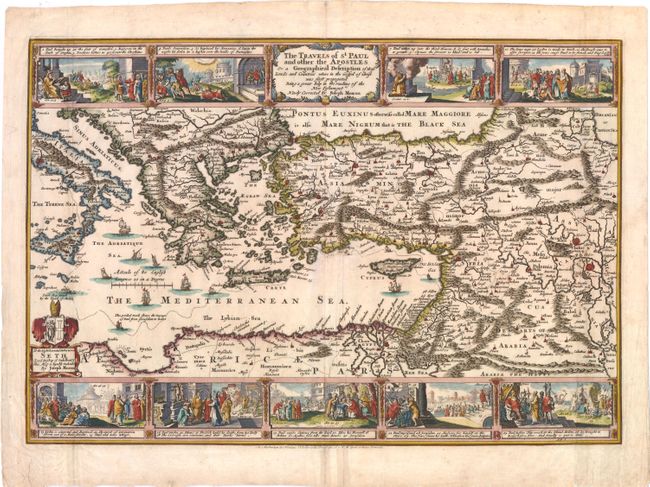
Subject: Eastern Mediterranean

Period: 1671 (circa)

Publication: Sacred Geographie or Scriptural Mapps

Color: Hand Color

Size:
18.3 x 12.6 inches
46.5 x 32 cm
Download High Resolution Image
(or just click on image to launch the Zoom viewer)

This map portrays the Eastern Mediterranean from Rome, through Asia Minor and the Holy Land, to Babylon. Territorial divisions reflect the political conditions of the first century A.D. The route of Apostle Paul is charted from Jerusalem to Rome. The decorative panels at top and bottom show the major events of Paul's journey; each vignette being a composite of two or three episodes. The one at the left of the cartouche shows Paul's conversion, his baptism by Ananias, and finally his daring escape from the city. Other scenes depict the young Paul before his conversion, healing the paralytic, his ship wreck at Malta, and his appearance before Nero. Moxon's map is an English version of Claes Visscher's 1648 map. Moxon dedicates the map to Seth Ward, Bishop of Salisbury. Published by Nicholas Visscher.

References: Laor #523; Shirley (BL Atlases) #G.MOX-1a [5].

Condition: B+

Watermarked paper with minor soiling, a few light creases, and some archivally repaired tears confined to blank margins.

Estimate: $275 - $350

Sold for: $200

Closed on 11/28/2012

Archived