Catalog Archive
Auction 142, Lot 412

"Reynolds's Map of London with the Latest Improvements", Reynolds, James

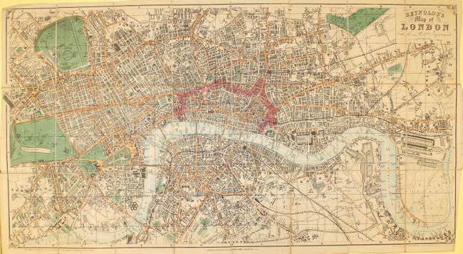
Subject: London, England

Period: 1848 (dated)

Publication:

Color: Hand Color

Size:
30.3 x 16.2 inches
77 x 41.1 cm
Download High Resolution Image
(or just click on image to launch the Zoom viewer)

This handsome 19th century map of London shows streets, canals, public buildings, docks, bridges and parks. The city of London is outlined in pink while the River Thames is shown flowing through the area from Chelsea Reach to Blackwall Reach. Includes an index to streets and attractions. The map is dissected and backed in linen and folds into green covers measuring 4 x 6".

References:

Condition: B+

There is an ink mark across the Thames to mark a bridge, light soiling, and minor creasing confined to the blank margins. Covers are slightly worn.

Estimate: $200 - $300

Sold for: $375

Closed on 11/28/2012

Archived