Catalog Archive
Auction 142, Lot 393

"A Mapp of the Sommer Ilands… / Mappa Aestivarum Insularum…", Speed, John
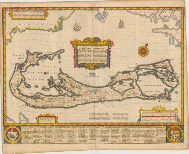
Subject: Bermuda

Period: 1676 (published)

Publication: A Prospect of the Most Famous Parts of the World…

Color: Hand Color

Size:
20.8 x 15.8 inches
52.8 x 40.1 cm
Download High Resolution Image
(or just click on image to launch the Zoom viewer)

This handsome map was compiled in 1622 by Richard Norwood. It is the first English printed map published in an atlas to show Bermuda divided into Tribes and Shares. These divisions designated the properties given to the 'Adventurers,' led by Sir George Sommers, who were shipwrecked there in 1609. Speed's map became the standard map of the 17th century and was copied by Blaeu, Jansson, Ogilby and others. The title is in both English and Latin. The map was beautifully engraved by Abraham Goos in Amsterdam for Speed's Prospect and his imprint appears below the scale of miles. The imprint of Bassett and Chiswell is at left. The map is embellished with sailing ships, a compass rose, four cartouches and two coats of arms. English text on verso.

References: Imago Mundi #40, p.140; Palmer (MCC-19) #6; Shirley (BL Atlases) #T-SPE-2f.

Condition: B

There is some show-through of text on verso and a few faint spots and light creases. There are a number of tiny tears in the blank margins that have been closed on verso with archival materials, including three that enter 1/4 to 3/4" into map image. A 1" chip at top right has been re-attached with archival materials.

Estimate: $2,100 - $2,500

Unsold

Closed on 11/28/2012

Archived