Catalog Archive
Auction 142, Lot 181

"A New and General Map of the Southern Dominions Belonging to the United States of America viz: North Carolina, South Carolina, and Georgia with … Louisiana and Florida", Laurie & Whittle

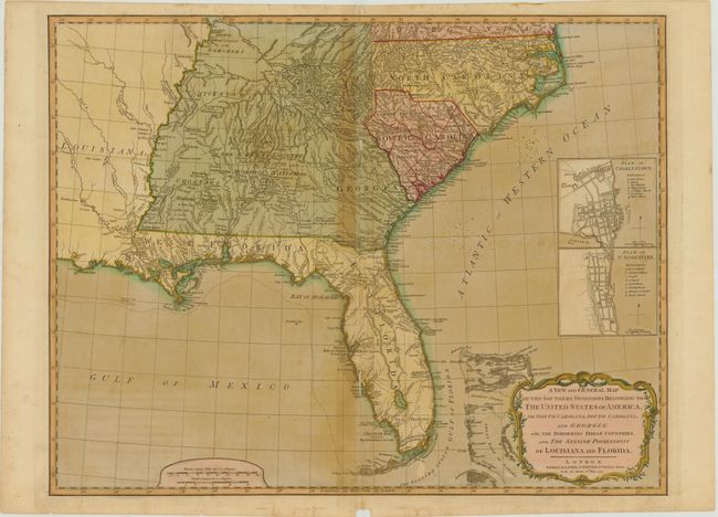
Subject: Southeast United States

Period: 1794 (dated)

Publication:

Color: Hand Color

Size:
24.8 x 19.5 inches
63 x 49.5 cm
Download High Resolution Image
(or just click on image to launch the Zoom viewer)

This is the second edition of this important map that was first published in 1776 in a British military atlas. In this edition the title has been revised to acknowledge the United States. The map is based on the work of De Brahm, Collet, Mouzon and the important hydrographical surveys of the coast of Florida and the Bahamas by Bernard Romans. It includes inset plans of St. Augustine and Charleston above the decorative title cartouche. The map is most noteworthy for its depiction of East and West Florida. The coastline of the Florida peninsula is accurately depicted but the interior remains virtually unknown with a spine of mountains, labeled the Great Sandy Ridge, extending down the center of the peninsula. The map is filled with information concerning the Indian Nations, with numerous trails, roads and villages located.

References: Tooley (Amer) pp. 98-9, #78-b.

Condition: B

Full original color on watermarked paper with light offsetting, toning along centerfold, and a small chip in bottom blank margin. There are some tiny ink spots in the Atlantic, and some short centerfold separations and adjacent tiny tears that have been closed with archival tape.

Estimate: $1,600 - $1,800

Sold for: $950

Closed on 11/28/2012

Archived