Catalog Archive
Auction 142, Lot 17

Rare World Map by Le Clerc

"Orbis Terrae Novissima Descriptio", Le Clerc, Jean
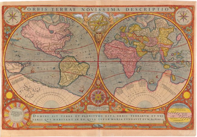
Subject: World

Period: 1602 (dated)

Publication:

Color: Hand Color

Size:
20.2 x 13.1 inches
51.3 x 33.3 cm
Download High Resolution Image
(or just click on image to launch the Zoom viewer)

This is the first of two world maps engraved by Jodocus Hondius for Parisian publisher Jean Le Clerc. The map is based on Rumold Mercator's double-hemisphere map from 1587 (see Shirley #157), which in turn was based on his father's great world map of 1569. The North Pole is depicted as a landmass surrounding a sea from which four rivers radiate and there is a well depicted Northwest Passage. There is a huge Terra Australis, and the lands of Maletur and Beach (from the travel account of Marco Polo) are noted along the coast in the vicinity of present-day Australia with a large island labeled Iava Minor located in the same region. Japan is shown in a kite-shaped configuration, with the fictitious Satyrorum insule (Satyr's Island) shown above. Hondius updated Mercator's map by eliminating the bulge in the southwest coast of South America and adding the islands of Queen Elizabeth at the southern tip. In addition, Hondius elongated New Guinea, added several islands to its east, and replaced the coastline between New Guinea and South America with a line of small islands.

The hemispheres are surrounded by an elaborate decorative border with an armillary sphere and 32-point compass rose tucked between the hemispheres. Hondius has balanced the title at top with one of his favorite quotations from the Psalms at bottom. The composition is completed with several diagrams in the corners, including two windroses with the wind names in Dutch and Italian, a diagram of the phases of the moon, and a final diagram of the climatic zones. Le Clerc's map was issued both separately and in editions of Mercator-Hondius atlases and Le Clerc's own atlas (Theatre Geographique du Royaume de France). This is the first state with the original date of 1602, which is considered quite rare. Blank verso.

References: Shirley #233.

Condition: B+

Watermarked paper with light toning, a few minute worm holes, and a professionally repaired centerfold separation that enters 2" into image at bottom. There are chips in bottom corners, just entering map border, that have also been professionally repaired, with a minor amount of neatline in facsimile and a 1" edge tear at left that has been repaired with old paper on verso.

Estimate: $5,500 - $6,500

Sold for: $4,000

Closed on 11/28/2012

Archived