Catalog Archive
Auction 141, Lot 388

Blaeu's Carte-a-Figures Map of Europe

"Europa Recens Descripta", Blaeu, Willem
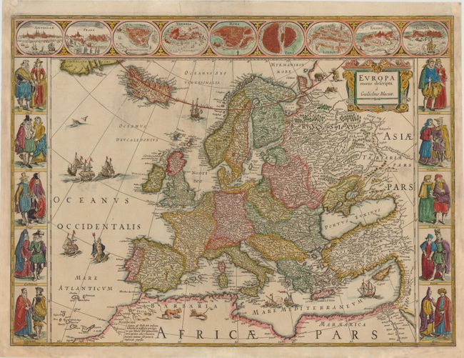
Subject: Europe

Period: 1630 (circa)

Publication:

Color: Hand Color

Size:
21.8 x 16 inches
55.4 x 40.6 cm
Download High Resolution Image
(or just click on image to launch the Zoom viewer)

This classic map of Europe is done in the carte-a-figures style with vignettes on three sides and no text on verso. Blaeu's carte-a-figures maps were issued separately, and then first used in an atlas in Blaeu's Atlantis Appendix in 1630. Examples with no text on verso are rare. Blaeu's atlases published after 1630 had text on the verso, which are more commonly found on the market. The upper frieze has nine bird's-eye views of Amsterdam, Prague, Constantinople, Venice, Rome, Paris, London, Toledo and Lisbon. The side borders contain the costumes of the noblemen and women of ten European nations. The map is embellished with sailing ships, sea monsters, bears and Neptune riding a dolphin and holding his trident. A beautiful map produced at the height of the Golden Age of Dutch mapmaking.

References: Goss (Blaeu) #4, p.30.

Condition: B

Remargined at right and left with a small amount of border and a portion of both bottom corners expertly replaced in facsimile. A centerfold separation that just enters map border at bottom and some chips in bottom blank margin have been professionally repaired. There is a light damp stain in an unengraved area of map image at right and some general light soiling.

Estimate: $3,000 - $4,000

Sold for: $2,750

Closed on 9/5/2012

Archived