Catalog Archive
Auction 141, Lot 256

"Showing the High and Low Water Mark and the Original City Grants of Lands Under Water Made to Various Parties from 1686 to 1873…", U.S. Coast Survey

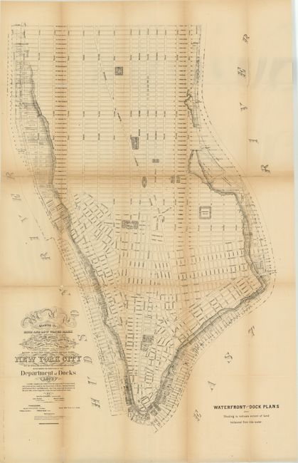
Subject: New York City, New York

Period: 1873 (dated)

Publication:

Color: Black & White

Size:
23 x 34 inches
58.4 x 86.4 cm
Download High Resolution Image
(or just click on image to launch the Zoom viewer)

The Office of Coast Survey is the oldest U.S. scientific organization, dating from 1807 when Congress directed that a "survey of the coast" be carried out. By 1836, it was called the U.S. Coast Survey and in 1878, the name was changed to the U.S. Coast and Geodetic Survey. Today the Office of Coast Survey is a division of the National Oceanic and Atmospheric Administration NOAA.

The survey teams, composed of civilians as well as Army and Naval officers, charted the nation's waterways and produced a wide array of reports, survey charts, hydrographic studies of tides and currents, astronomical studies and observations, and coastal pilots. These charts are an important record of the changing nature of the nation's coastlines. In additional to coastal charts, the U.S. Coast and Geodetic Survey produced land sketches, Civil War battle maps, and the early aeronautical charts.

Interesting map of Lower Manhattan showing the early land grants that were originally under water and reclaimed by the city for the rapidly evolving shipping industry. Numerous docks and slips are noted as well as important buildings. Drawn based upon U.S. Coast Surveys as well as surveys made by the city's Department of Docks. Surveyed by Gen. Charles K. Graham, Engineer in Chief of the port of New York.

References:

Condition: C+

Issued folding with light toning along the folds and numerous fold separations, some of which are closed on verso with archival material, with a couple of tiny areas of loss.

Estimate: $100 - $130

Sold for: $75

Closed on 9/5/2012

Archived