Catalog Archive
Auction 140, Lot 200

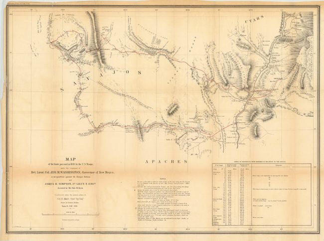
"Map of the Route Pursued in 1849 by the U.S. Troops, under the Command of Bvt. Lieut. Col. Jno. M. Washington, Governor of New Mexico, in an Expedition Against the Navajos Indians", Simpson/Kern

Subject: Southwestern United States

Period: 1849 (dated)

Publication: Navajo Journal, 31st Congress, 1st Session, Senate Exec. Doc. No.64

Color: Black & White

Size:
27.5 x 20 inches
69.9 x 50.8 cm
Download High Resolution Image
(or just click on image to launch the Zoom viewer)

This map is the product of a punitive expedition against marauding Navajo Indians. The expedition traveled from Santa Fe to Jemez Pueblo, then on the Navaho trail to Chaco Canyon, and via Washington Pass to Canyon de Chelly. They engaged the Navajo in their strongholds at Chaco Canyon and Canyon de Chelly where the tribe was soundly defeated. The soldiers then explored the area and were the first white men to discover and describe the prehistoric pueblos in the region. The return route traveled south of the Zuni Pueblos and east past Inscription Rock and Laguna Pueblo to the Rio Grande. A seldom seen map that Wheat calls "an arresting production, bringing out many new details of the region."

References: Wheat (TMW) #641.

Condition: B

There is a 1" binding tear at upper left and a 0.25" edge tear at top left, both of which have been closed on verso with archival tape. The top left corner is chipped, just passing the neatline and there is some light toning primarily along a few folds. Fold intersections have been reinforced with archival tape on verso.

Estimate: $450 - $550

Sold for: $325

Closed on 5/23/2012

Archived