Catalog Archive
Auction 140, Lot 109

Keystone Map for Great Lakes Collections

"Le Canada, ou Nouvelle France, &c.", Sanson, Nicolas

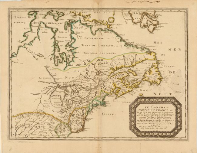
Subject: Colonial United States and Canada - Great Lakes

Period: 1656 (dated)

Publication:

Color: Hand Color

Size:
21.5 x 15.8 inches
54.6 x 40.1 cm
Download High Resolution Image
(or just click on image to launch the Zoom viewer)

This is one of the most influential seventeenth century maps of the French and English colonies in North America. It concentrates on the region of greatest French interest with the boundary lines reflecting the French version of territorial boundaries. Sanson based the map primarily on Jesuit sources, retaining Champlain's basic cartographic model for the northern parts of Canada. He added some nomenclature of James, Foxe, and Button and retained the earlier concept of Button's Northwest Passage, in the southwest corner of the bay. The most important aspect of the map is the first appearance of L. Erie, ou du Chat as a recognizable lake. This delineation influenced the cartography of the region for over 100 years and was not superceded until Delisle's Carte du Canada in 1703. The entire Great Lakes basin and the St. Lawrence River are shown in great detail. Lake Superior and Michigan (Lac du Puans) are left open-end to the west. Other geographical improvements introduced with this map include a more detailed Hudson Bay, the introduction of Long Island, and the correct position of New Amsterdam. Engraved by Jan van Somer.

References: Burden #318; Kershaw #133; Schwartz & Ehrenberg #62; Pastoureau, Sanson V [86].

Condition: B+

Original outline color on watermarked paper with light toning along centerfold and a printer's crease at bottom left. There is an extraneous crease at left and two unobtrusive manuscript ink marks at top left. Remnants of paper hinge tape on verso.

Estimate: $4,750 - $6,000

Sold for: $3,000

Closed on 5/23/2012

Archived