Catalog Archive
Auction 136, Lot 408

"Carte Topographique de l'Ile de Saint Jean de Puertorico et de l'Ile de Bieque…", Lopez de Vargas Machuca, Thomas (don)

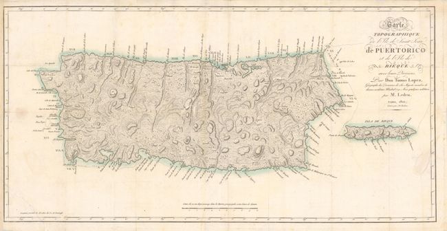
Subject: Puerto Rico

Period: 1810 (dated)

Publication:

Color: Hand Color

Size:
28 x 14 inches
71.1 x 35.6 cm
Download High Resolution Image
(or just click on image to launch the Zoom viewer)

This is the French reissue of Lopez' 1791 map of Puerto Rico, updated by M. Ledru. The map covers the entire island of Puerto Rico and Vieques Island. There is nice detail of towns, watershed, anchorages and hazards. The hills and mountains are shown in extensive hachure.

References:

Condition: B

Tear in the bottom left corner of image has been professionally repaired. A few damp stains and minor spotting in the image. Issued folded and now flattened.

Estimate: $1,000 - $1,200

Sold for: $750

Closed on 6/1/2011

Archived