Catalog Archive
Auction 136, Lot 350

Rare Texas Oilfield Map

"Geological Map of Texas Showing Approximate Locations and Drilling Wells. Also Names the Companies Drilling",

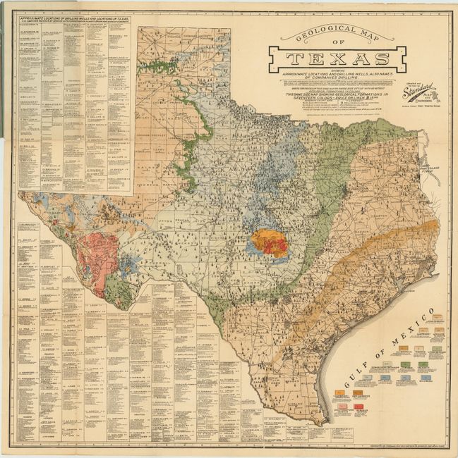
Subject: Texas Oil Fields

Period: 1920 (dated)

Publication:

Color: Printed Color

Size:
18 x 20 inches
45.7 x 50.8 cm
Download High Resolution Image
(or just click on image to launch the Zoom viewer)

This scarce pocket map focuses on the burgeoning oil and gas business in Texas. The title continues "the Locations and Names of Wildcat Wells Contained Hereon were Obtained from sources we consider Reliable." The map locates a huge number of Drilling Wild Cat (wells), each shown by individual, small oil derricks. Legend also locates Producing Oilfields and Railroads. A wide pallet of colors indicate seventeen different geological formations, with the oil and gas fields located and railroads delineated. Large table, occupying most of the left side, lists all of the oil drilling activity fields by county and drilling company keyed to the map. Although oil was known to exist in Texas as early as 1543, the oil boom in Texas and Oklahoma began in earnest in the early part of the 20th century. The map folds into original blue paper covers with the title "New Oil and Geological Map of Texas". Blank inside cover, back cover lists the products and services of the company including "Over 200 Texas - Louisiana - New Mexico and Oklahoma Oil Maps," a remarkable number of maps by any measure. This rare commercially produced pocket map is copyright May 1920 by the Standard, Blue Print, Map & Engineering Company, 515 Main Street, Fort Worth.

References:

Condition: B+

Strong color and original margins, but there are some short fold intersection splits. Cover spine is split about 2.5" from top.

Estimate: $600 - $800

Sold for: $5,000

Closed on 6/1/2011

Archived