Catalog Archive
Auction 136, Lot 344

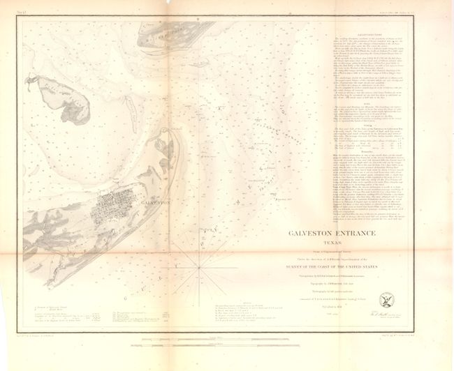
"Galveston Entrance Texas From a Trigonometrical Survey…", U.S. Coast Survey

Subject: Texas

Period: 1856 (dated)

Publication:

Color: Black & White

Size:
17 x 13.5 inches
43.2 x 34.3 cm
Download High Resolution Image
(or just click on image to launch the Zoom viewer)

The Office of Coast Survey is the oldest U.S. scientific organization, dating from 1807 when Congress directed that a "survey of the coast" be carried out. By 1836, it was called the U.S. Coast Survey and in 1878, the name was changed to the U.S. Coast and Geodetic Survey. Today the Office of Coast Survey is a division of the National Oceanic and Atmospheric Administration NOAA.

The survey teams, composed of civilians as well as Army and Naval officers, charted the nation's waterways and produced a wide array of reports, survey charts, hydrographic studies of tides and currents, astronomical studies and observations, and coastal pilots. These charts are an important record of the changing nature of the nation's coastlines. In additional to coastal charts, the U.S. Coast and Geodetic Survey produced land sketches, Civil War battle maps, and the early aeronautical charts.

This coastal survey chart details the entrance to Galveston Bay. It includes a town plan of Galveston without streets named. The chart extends to Pelican Island, Bird Key, and Bolivar Point. It locates buoys, a beacon, a light boat, and is filled with soundings, bottom types and extensive notations on sailing directions. Triangulations were completed by R.H. Fauntleroy and J.S. Williams.

References:

Condition: B+

Folding as issued with light toning and a fold intersection split.

Estimate: $140 - $170

Sold for: $80

Closed on 6/1/2011

Archived