Catalog Archive
Auction 135, Lot 293

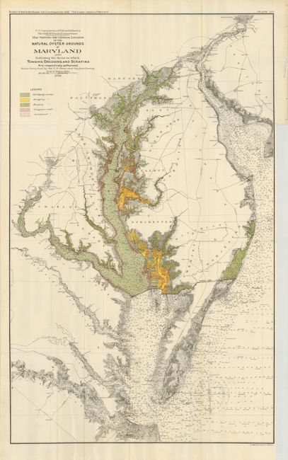
"[Lot of 2] Map Showing the General Location of the Natural Oyster Grounds of Maryland… [with] The Oyster Industry of Maryland", U.S. Government

Subject: Maryland

Period: 1893 (dated)

Publication: Bulletin of the United States Fish Commission

Color: Printed Color

Size:
22 x 35 inches
55.9 x 88.9 cm
Download High Resolution Image
(or just click on image to launch the Zoom viewer)

This colorful chart details oyster fishing beds throughout Chesapeake Bay and part of Chincoteague Bay in remarkably fine detail. The map locates Washington, D.C., Annapolis, Baltimore and Philadelphia in street grid pattern. It locates areas where oyster gathering is authorized, and by which method, as shown by the color coded key at upper left to include Dredging, Scraping or Tonging. The legend also locates Compact and Scattered Reefs. By the 1870's, Maryland's oyster fields were becoming severely depleted, which led to oyster management efforts in the form of laws and regulations. This lot is complete with the original report "The Oyster Industry of Maryland" by Charles H. Stevenson. The disbound report contains 297 pp and 14 plates describing and illustrating the oyster industry and the ships and canoes used. Includes images of a Chesapeake Bay Tonging Canoe, a Tonging Bug-Eye, Dredging Vessel, Oyster Marketing Establishment at Baltimore, also with several photographs of men and women working in large shucking rooms.

References:

Condition: A+

Map and report are fine, flawless.

Estimate: $250 - $300

Sold for: $190

Closed on 2/16/2011

Archived