Catalog Archive
Auction 135, Lot 281

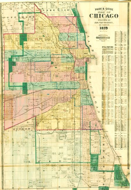
"Park & Guide Map of Chicago…",

Subject: Chicago, Illinois

Period: 1873 (dated)

Publication:

Color: Hand Color

Size:
30.8 x 46 inches
78.2 x 116.8 cm
Download High Resolution Image
(or just click on image to launch the Zoom viewer)

This pocket map shows the extent of the Great Fire of 1871 with red hand coloring. Overall, the map shows enormous detail including all streets and subdivisions named. The map extends from Englewood in the south to Lakeview, and as far west as Lawndale and Central Park. The large table at right is the Official Street Guide, dated November 25, 1872. This rare map was published by Jas. Van Vechten, 124 Clark St. It was engraved and printed by Jerome T. Gouget, Map Engraving Specialty Lithographer Map Drafting, 502 Dearborn Street. The title carries the engraved date "1873" but this map has ink over the numerals in an apparent attempt to change this to 1879. It is not clear if this was done by the publisher or an owner. Fancy banknote-style boarder. Folds into original red cloth boards with paper label on front with title in gilt. Blank inside cover with no advertising. This map appears in Phillips but we find no example in collections or any prior sales. Apparently a rare issue by an uncommon publisher.

References: Phillips (M) p. 230.

Condition: B+

The map presents well for a map of this size. It has fine, strong color and only small flaws that do not detract from its appearance. A few small splits and along the lower fold and an area of toning with very small loss at fold intersections with tissue applied to verso for support. Covers are worn but structurally sound.

Estimate: $400 - $600

Sold for: $700

Closed on 2/16/2011

Archived