Catalog Archive
Auction 135, Lot 143

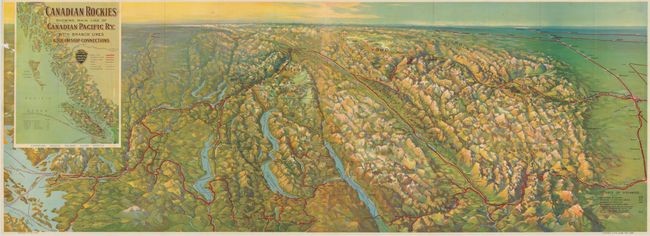
"Canadian Rockies Showing Main Line of Canadian Pacific Ry. with Branch Lines & Steamship Connections", Railroad Companies, (Various)

Subject: Western United States and Canada

Period: 1926 (dated)

Publication:

Color: Printed Color

Size:
46.6 x 16.7 inches
118.4 x 42.4 cm
Download High Resolution Image
(or just click on image to launch the Zoom viewer)

This is a stunning bird's-eye view from the south that shows the Pacific Northwest and all the way to Edmonton, Alberta on the far horizon. The map shows Seattle at lower left, extends from the Cascade Mountains to show Okanogan Lake, Upper & Lower Arrow Lake, Kootenay Lake, the Kootenay River Valley, and across the Rocky Mountains to Calgary. Further north are Spence's Bridge, Kamloops, Revelstoke, Glacier Park, Yoho Park and Banff Park. Beautiful 3-D effect shows hundreds of mountains and all of the major rivers and lakes. Important places such as the Banff Spring Hotel are illustrated. At the far horizon is Ullin, the Rocky Mountain House; Quesnel and Barkerville at the end of the important Caribou Road. The title incorporates an inset map of the coastal region showing from Vancouver Island to Haines. This is a very finely rendered and colorful gravure image. This large pocket map folds into original tan paper covers "Panoramic Map of the Canadian Pacific Rockies. Issued by the Canadian Pacific Railway 1926." Printed in Canada.

References:

Condition: B+

The folding view is very nice except for a small area of loss at left margin, otherwise fine. Map is loose from cover. Covers are soiled with repair on rear cover.

Estimate: $100 - $150

Sold for: $170

Closed on 2/16/2011

Archived