Catalog Archive
Auction 134, Lot 147

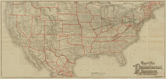
"General Map of the Pennsylvania Railroad and its Connections", Railroad Companies, (Various)

Subject: United States

Period: 1884 (dated)

Publication:

Color: Printed Color

Size:
35 x 16.3 inches
88.9 x 41.4 cm
Download High Resolution Image
(or just click on image to launch the Zoom viewer)

Dated April 16th, 1884, this railroad timetable and map self-folds into a pictorial cover featuring an engraving of steam locomotives traversing Horseshoe Curve in the Allegheny Mountains. The map includes most of the United States and details the route and connecting lines for the Pennsylvania Railroad. The main routes are shown as bold lines between Philadelphia, Toledo, Rochester, Chicago, St. Louis, Cincinnati, Baltimore and Washington D.C. The lines of connecting railroads form a dense network that stretches westward to the Pacific at San Francisco and Los Angeles. Each railroad is named with hundreds of rail stations located and likewise named. The title is in fancy Victorian-style lettering. On the verso are 18 panels devoted to the timetable, two large engravings: Pullman's Sleeping Car and Pennsylvania Railroad Dining Car, and advertisements for various routes. The timetable side is printed in red and black. Printed by Allen, Lane & Scott of Philadelphia.

References:

Condition: B+

Splits along some fold panels.

Estimate: $120 - $180

Sold for: $190

Closed on 12/1/2010

Archived