Catalog Archive
Auction 133, Lot 280

"Plan of the Seat of War - Map of the Rio Grande, Matamoros, Brazos Santiago & Point Isabel", U.S. War Department
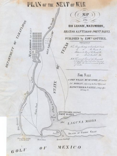
Subject: Texas

Period: 1846-47 (circa)

Publication:

Color: Black & White

Size:
8 x 10.5 inches
20.3 x 26.7 cm
Download High Resolution Image
(or just click on image to launch the Zoom viewer)

Mexican American War map that locates Matamoros and the surrounding vicinity to the Gulf of Mexico to include the Rio Grande River. Locates General Taylor's camp near Matamoros and his depot at Point Isabel. Names the villages of Los Taraeses, Burrita, Pando, Boca chica and Puerto, as well as the Island of Padre Vally and the Mexican Department of Tamaulipas. The map delineates numerous wagon roads, with the streets of Matamoros shown in a grid pattern. This is the New Orleans edition that was apparently printed by Manouvrier & P. Snell on Camp Street. It was published by Edward Gottheil and sold at John Willis' Music Store on Canal Street and by J.C. Morgan "Adjoining the Post Office."

References:

Condition: B

Issued folded, now flattened. On thin, blue banknote quality paper. Part of upper 1/2" of map with brown stain along the title "Plan of the Seat of War." Tear at binding trim closed on verso with old tape repair, no tape staining on recto.

Estimate: $350 - $500

Sold for: $180

Closed on 9/1/2010

Archived