Catalog Archive
Auction 133, Lot 219

"Sketch of Capt. Gunnison's Route to Sept. 20, 1853 Central Pacific Railroad Exploration [together with report].", U.S. War Department
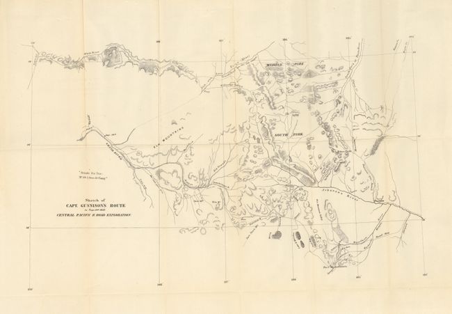
Subject: Colorado

Period: 1853 (dated)

Publication: Pacifc Railway Surveys

Color: Black & White

Size:
20 x 13 inches
50.8 x 33 cm
Download High Resolution Image
(or just click on image to launch the Zoom viewer)

Issued in the scarce preliminary octavo edition of the Pacific Railroad Surveys that preceded the quarto edition by over a year. Wheat mentions the map on page 202 under the much larger Gunnison & Beckwith map (TMW #842) that covers from St. Louis to San Francisco. On this earlier map the central region of Colorado is several times more detailed. The route follows the Arkansas River valley to includes today's La Vita Pass, Garland, Gunnison and the vicinity of Grand Junction. The last camp is dated September 20th. Barely five weeks later Gunnison and Kern were killed near Siever Lake, Utah. The map is still in the rear pocket of the original Report of the Secretary of War, 33rd Congress, 1st Session, Ex Doc 29.

The report is complete with two additional maps in the rear pocket: 1. Sketch of the Progress of the Northern Pacific Railroad Exploration up to the crossing of the Shayen River, (26 x 16"). Signed in the plate by Isaac Stevens. Folding as issued with a long split on one fold, tear at binding trim and some toning and offsetting. 2) Sketch of the Northern Pacific Railroad from St. Paul to Ft. Union, (32 x 18"). Large folding map with a few typical flaws including a couple small fold intersection splits and light fold toning. The 118 pp. report is dated February 6, 1854. It is in fine, modern binding in blue cloth with leather spine and corners. Gilt titling along spine. Contents very good and tight except one signature split from remainder with cloth spine intact.

References: Koepp No.I-127-2-4

Condition: B+

Very nice example, folding as issued. Small area (1/2") of loss at paper edge on binding trim over 2" away from map image. Some binding side roughness to paper edge at top. See description for condition of the report volume and other maps.

Estimate: $350 - $400

Sold for: $600

Closed on 9/1/2010

Archived