Catalog Archive
Auction 133, Lot 194

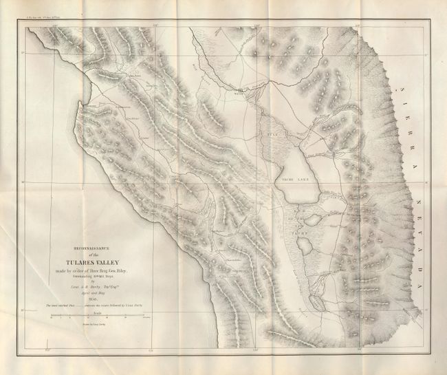
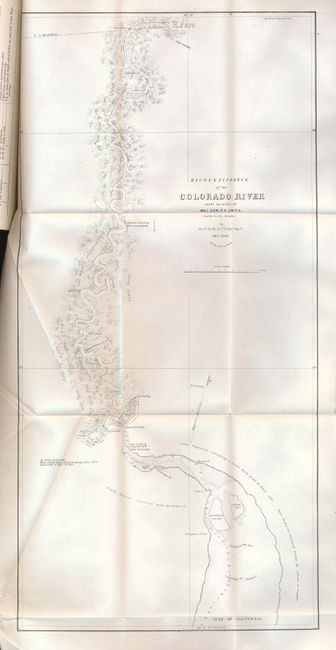
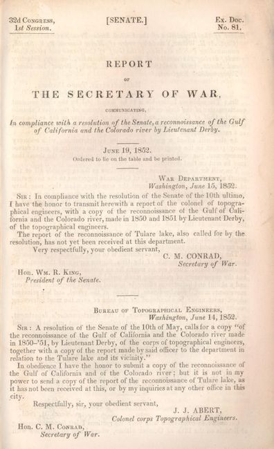
"Reconnaissance of the Tulares Valley Made by order of Brev. Brig. Gen. Riley… [and] Reconnaissance of the Colorado River made by order of Maj. Gen. P.F. Smith…", Derby, George Horatio (Lt)

Subject: California and Arizona

Period: 1850 (dated)

Publication: Sen. Doc. 110, 32nd. Cong., 1st Sess.

Color: Black & White

Size:
18 x 14.8 inches
45.7 x 37.6 cm
Download High Resolution Image
(or just click on image to launch the Zoom viewer)

These two important maps of exploration by Lt. Derby are contained in the original Report of The Secretary of War…a reconnaissance of the Gulf of California and the Colorado river by Lieutenant Derby., 32d Congress, 1st Session, Senate Ex. Doc. 81; 8vo, 28 pp. with modern blue cloth boards and paper label on spine. Both maps are dated 1850 but were not published until 1852 when this report was released.

The first map delineates the area south of the San Joaquin River from the Pacific Ocean to the foothills of the Sierra Nevada Mountains. The Road to Los Angeles runs through the center of the map. This road offers two routes to LA on either side of Tache Lake with the eastern-most route running along the base of the Sierra Nevada Mountains. The road from Monterey to San Louis Obispo names several villages along the way including Tores, Guadalupe, Soledad, Ojitas and Paso de Rables (sic). Derby's route is traced by dashed lines and several mountain passes are noted. Further, the map locates Warsaw on the road to Los Angeles at the River San Joarquin, and other interesting features such as "Wild Horses." Wheat calls this a map of major importance to the California Gold Rush.

Also bound in the Report is the original second map Reconnaissance of the Colorado River made by order of Maj. Gen. P.F. Smith.. (11 x 22"). A provision of the Treaty of Guadeloupe Hidalgo that ended the war with Mexico gave the United States navigation rights in the Gulf of California and up the Colorado River. Lt. George H. Derby, Corps. of Topographical Engineers, was assigned the task to reconnoiter the mouth of the river and determine the navigability as far north as Camp [Fort] Yuma. Located at the confluence of the Colorado and Gila Rivers, Yuma was one of the great natural crossroads of the Southwest and Derby's map served to focus attention on the area just as throngs of gold seekers chose this route to California. The map locates Indian villages, landings, and conditions along the winding course of the river. A historically significant map that delineates the Colorado River from its confluence with the Gila River to its mouth in the Gulf of California. Wheat describes this map as "interesting and useful" and notes that it was the basis for cartography of that area until the Ives maps appeared a decade later in 1860.

References: Wheat (Gold) #150; Wheat (TMW) #668.

Condition: A

A beautiful example. Both maps are clean and bright, and in fine condition less a short binding trim tear on the Tulare map. Bound in original location in the report. Text pages are generally clean but some have a light damp stain at outside edge. New binding is mint.

Estimate: $250 - $350

Sold for: $1,100

Closed on 9/1/2010

Archived