Catalog Archive
Auction 132, Lot 206

"Map Showing Crofutt's Overland Tours", Crofutt, George A.

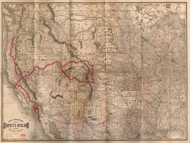
Subject: Western United States

Period: 1888 (dated)

Publication:

Color: Black & White

Size:
22.3 x 16.5 inches
56.6 x 41.9 cm
Download High Resolution Image
(or just click on image to launch the Zoom viewer)

This is Crofutt's Tour book No.2 which includes a very detailed Rand McNally map of the U.S. west of the Mississippi, titled as given above. The folding map follows the book's planned tours No.2 through No. 41 as shown in red overprinting. The routes include a large loop through Salt Lake City, Pueblo, Denver and Cheyenne, west from Salt Lake through Nevada splitting at Sacramento north to Portland, south to San Diego, utilizing portions of the Union Pacific, Central Pacific, Denver & Rio Grande, Southern Pacific and the Atchison, and the Topeka & Santa Fe Railways. The text gives detailed information of cities, towns, villages, stations, government forts and camps for the westbound traveler on the Central Pacific Railroad. There are numerous wood-engraved illustrations, six of which are double page. The map folds into the book (5" x 9") with soft cloth covers, 256pp, index.

References:

Condition: B+

The covers have wear and soiling. Internally there is occasional foxing (mostly confined to the margins), some old pencil notes, and rear inside hinge has archival tape support. The map has a 2" closed tear, some age toning and a few areas of light foxing.

Estimate: $120 - $150

Sold for: $60

Closed on 6/2/2010

Archived