Catalog Archive
Auction 132, Lot 187

"Report… in Relation to the Protection of the Western Frontier of the United States [with maps]", Hood, Washington (Lt.)

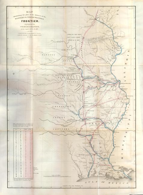
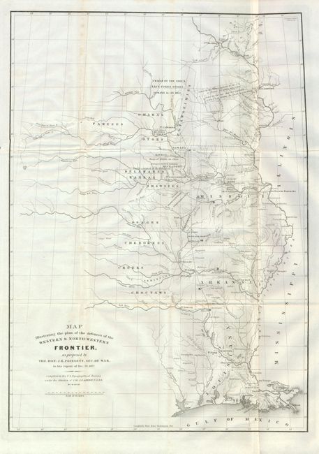
Subject: Central United States

Period: 1837 (dated)

Publication: Senate Doc 65, 25th Cong., 2nd Session

Color:

Size:
6 x 9 inches
15.2 x 22.9 cm
Download High Resolution Image
(or just click on image to launch the Zoom viewer)

This is the Senate report by Secretary of War J.R. Poinsett that contains the two important 'Western Defenses' maps by Gratiot and Poinsett. These maps illustrate the factious Congressional debate over the nature of the frontier defenses in the region between the Mississippi River and the Rocky Mountains. Issued under the direction of Col. A.A. Abert by W. Hood, the maps covers the states of Missouri, Arkansas and Louisiana and the Indian nations bordering them to the west. Locates many military forts and outposts from Ft. Jessup to Ft. Snelling with notations throughout concerning the regions ceded by several Indian nations with the dates of the treaties. Locates numerous Indian Tribes in relation to the nearby and encroaching cities and growing settlement areas. The threat posed by hostile Indians whose numbers greatly exceeded those of the settlers in the area, resulted in a protracted Congressional debate concerning the defenses required along the frontier. This report contains: Map Illustrating the Plan of the Defences of the Western & North-Western Frontier, as proposed by Charles Gratiot, in his report of Oct. 31, 1837 (15 x 21.3"), which uses color to trace the common roads and rivers. A table at lower left notes the distances between forts and the equivalent "days of march" at 15 miles per day; and Map Illustrating the Plan of the Defences of the Western & North-Western Frontier, as proposed by The Hon. J. R. Poinsett, Sec. of War in his report of Dec. 30, 1837; black & white, (15 x 21.3"). 8vo, modern cloth, 19pp, two maps. This is the first and most desirable printing of these maps and should not be confused with a later printing (ca. 1860) in the American State Papers.

References: Wheat (TMW) #426 & 427.

Condition: A

The Gratiot map has a little toning or foxing along lower fold near the lower left table, otherwise fine. The Poinsett map is also very nice except for one fold with very light toning and a tear at left entering map about 3" that is closed on verso with archival tape. It is loose from the report.

Estimate: $300 - $400

Sold for: $275

Closed on 6/2/2010

Archived