Catalog Archive
Auction 131, Lot 500

"Comic Map of the Seat of War with Entirely New Features",
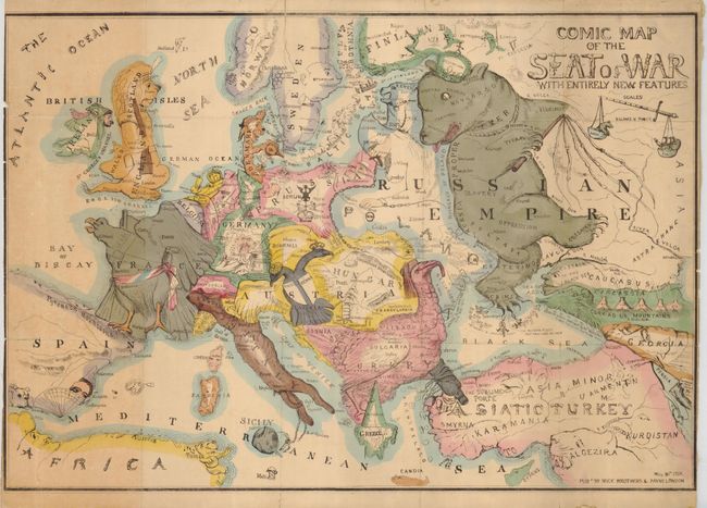
Subject: Europe

Period: 1854 (dated)

Publication:

Color: Hand Color

Size:
26.7 x 18.3 inches
67.8 x 46.5 cm
Download High Resolution Image
(or just click on image to launch the Zoom viewer)

Satirical maps have their roots in the 16th century but gained popularity in the nineteenth century with the political caricature map. This is one of the earliest such caricature map of Europe showing the political situation at the time of the Crimean War.

The major players in the conflict are boldly caricatured and the map is filled with scores of interesting and humorous symbols. The Russian Bear, wearing the Imperial crown labeled Despotism, brandishes a cat-o-nine-tails whip as he marches towards Asia while looking over his shoulder to Europe. The bear’s right foot forms the Crimean peninsula where the French and English fleets gather to clip the bear’s claws. The Caucasus appear as a series of cork-exploding volcanoes (Cork As Us Mountains), a reference to the perennial political unrest in the region. In Europe, the Balkans appear in the form of a Turkey wearing a fez and clutching a bottle of port labeled Constantinople. France appears as the Imperial Eagle (a reference to Emperor Napoleon III) girded in a ceremonial sash. The British Isles take the form of an armed lion with Ireland a ragged peasant figure. An English fleet is shown entering the Gulf of Finland, a reference to the British Prime Minister's use of gunboat diplomacy. Italy takes on the form of a running dog, wearing the papal crown. The double-headed eagle of Austria, looks both east and west, a reference to Austrian neutrality and clumsy attempts at diplomacy shown in a variety of notes tucked under the eagle's wings and in its beaks. The other European countries form a variety of comical figures. The scale of miles is formed by a sword and balance scale depicting Russia on one side and The Allied Powers on the other. It would take a good deal of study to understand the totality of this map's political and satirical nuances. Published by Rock Brothers & Payne in London, May 30, 1854. While it is dated earlier than a German map titled Komische Karte des Kriegsschauplatzes that Roderick Barron cataloged as circa 1856, it is unclear which map was published first. Both maps have rarely been seen on the market.

References:

Condition: B

Backed with linen, apparently as issued. The map is lifted from the linen at edges and there are some short tears and fold separations into the map. There is some minor toning at left. The map is stable as is, but deserves the attention of a conservator.

Estimate: $1,500 - $1,900

Sold for: $3,750

Closed on 3/17/2010

Archived