Catalog Archive
Auction 131, Lot 404

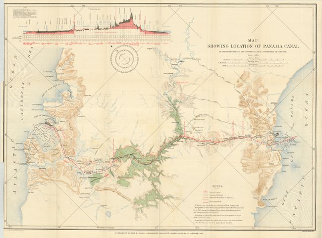
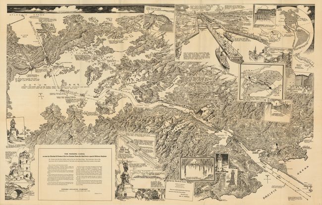
"[Lot of 2] Map Showing Location of Panama Canal as Recommended by the Isthmian Canal Commission of 1899-1902 and The Panama Canal…",

Subject: Panama Canal

Period: 1905-1925 (dated)

Publication:

Color:

Size:
See Description
Download High Resolution Image
(or just click on image to launch the Zoom viewer)

The first is by Andrew B. Graham & Co., 1905, printed color, 32" x 23.8". This great Panama Canal map was made after the French construction efforts were abandoned and in the first year of work by the U.S. It details the canal and proposed ship route from Colon to Gatun, Bohio, Gorgona, Emperador and into the Gulf of Panama at Panama City. The legend identifies the Line of the Canal, the Panama Railroad, Proposed diversion of Railroad and River. With printed colors to depict water, forests, ocean and topography. Red overprinting is used to delineate the canal with mileposts and other canal related construction. At upper left is a colorful profile giving much more information than most. Three distance scales and a large compass rose with variation. The French, who had abandoned their efforts by 1899, had already excavated nearly 60 million cubic meters of earth. Before the project was completed more than 215 cubic meters were excavated by a work force that reached, at its peak, 39,000 people. This fine Panama Canal map was published as a Supplement to the National Geographic Magazine in October 1905. Very short tear at binding trim, closed on verso and a trace of offsetting in blank areas (A).

The second map's title continues "as seen by Charles H. Owens of the Los Angeles Times Art Staff from a special Military Airplane", b&w, 1925, 42" x 27". Published by the Panama Railroad Company which says "Mr. Owens was the first civilian artist to fly over the Canal Zone. This bird's-eye view of the big canal, with its inserted sketches of the locks and interesting Canal Zone scenes is the result." It is a remarkably detailed high view that stretches from Colon to Balboa and the City of Panama. Insets include a typical gate (lock), the entrance with two large freighter's about to enter the canal's twin locks, old Spanish ruins including part of Old Panama City as destroyed by the pirate Captain Morgan. And an inset map showing the canal and sailing routes in the western hemisphere. Folding as issued with original brown mailing envelope (unused). We have not before encountered this uncommon issue. No significant flaws (A).

References:

Condition:

See individual descriptions.

Estimate: $200 - $300

Sold for: $140

Closed on 3/17/2010

Archived