Catalog Archive
Auction 126, Lot 660

"Geographische Beschryvinghe, van de Wandeling der Apostelen ende de Reysen Pauli…", Visscher, Nicolas

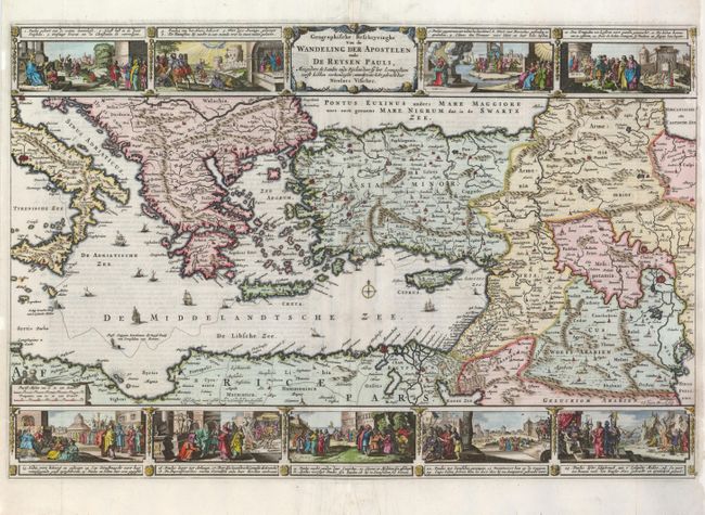
Subject: Eastern Mediterranean & Middle East

Period: 1657 (circa)

Publication:

Color: Hand Color

Size:
19 x 12.5 inches
48.3 x 31.8 cm
Download High Resolution Image
(or just click on image to launch the Zoom viewer)

This colorful map portrays the Eastern Mediterranean from Rome, through Asia Minor and the Holy Land, to Babylon. Territorial divisions reflect the political conditions of the first century A.D. The route of Apostle Paul is charted from Jerusalem to Rome. The decorative panels at top and bottom are taken from the elder Visscher's similar map. They show the major events of Paul's journey; each vignette being a composite of two or three episodes. The one at the left of the cartouche shows Paul blinded on the road to Damascus, his baptism by Ananias, and finally his daring escape from the city. Other scenes depict the young Paul before his conversion, healing the paralytic, his ship wreck at Malta, and his appearance before Nero. Engraved by A. vanden Broeck, first state. Dutch text on verso.

References: Poortman & Augusteijn #123.

Condition: B+

The side margins have been professionally restored with a small part of the border of the upper right vignette replaced is expert facsimile.

Estimate: $275 - $350

Sold for: $275

Closed on 12/3/2008

Archived