Catalog Archive
Auction 126, Lot 189

"Map of the Southern States, Including Railroads, County Towns, State Capitals, County Roads, the Southern Coast from Delaware to Texas, Showing the Harbors, Inlets, Forts and Position of Blockading Ships…", Harper's Weekly

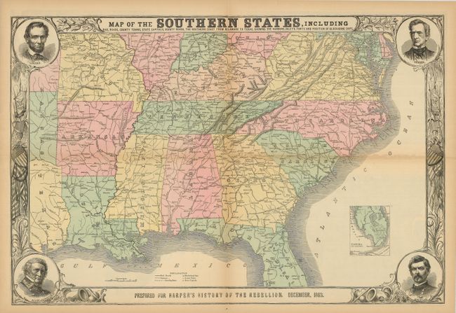
Subject: Southern United States

Period: 1863 (dated)

Publication: Harper's History of the Great Rebellion

Color: Hand Color

Size:
30 x 20 inches
76.2 x 50.8 cm
Download High Resolution Image
(or just click on image to launch the Zoom viewer)

This terrific Civil War map shows good detail of the towns, villages, railroads, and the ship blockade of the south. The title continues along the bottom: "Prepared for Harper's History of the Rebellion. December, 1863." Surrounded by a very decorative border, it features portraits at each corner of Lincoln, Seward, Gen. Scott, and Gen. McClellan. An inset of "Florida. Southern Part." lies at lower right. On the verso are three black and white wood engraved birds-eye views, two single page and a large double page. The double page view details the region around the Chesapeake Bay and is titled "Pictorial Map of Portions of Delaware, Maryland, Virginia, and North Carolina…" The other two are "Balloon View of Fortress Monroe and Hampton Roads" and "Balloon View of the Seat of War." An uncommon issue.

References: Stephenson (CW) 14.55, 32.9, 37.

Condition: B

The map is a little tender along two folds with archival tape on verso. A few short marginal tears and toning on some folds. Very nice original hand coloring and full margins. Printed on fragile newsprint, it will benefit from professional attention. Shows much better than the condition suggests.

Estimate: $200 - $250

Sold for: $150

Closed on 12/3/2008

Archived