Catalog Archive
Auction 125, Lot 89

"A Chart of North and South America, Including the Atlantic and Pacific Oceans, with the Nearest Coasts of Europe, Africa, and Asia", Jefferys/Sayer & Bennett

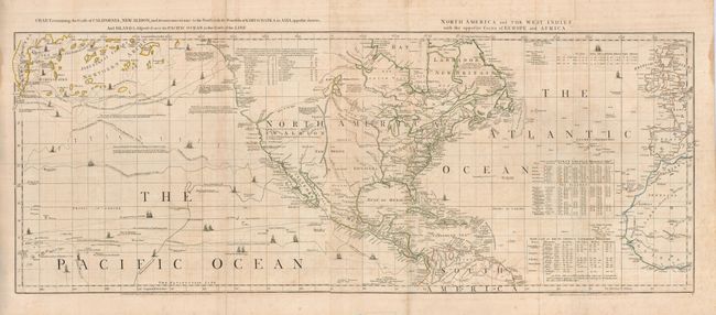
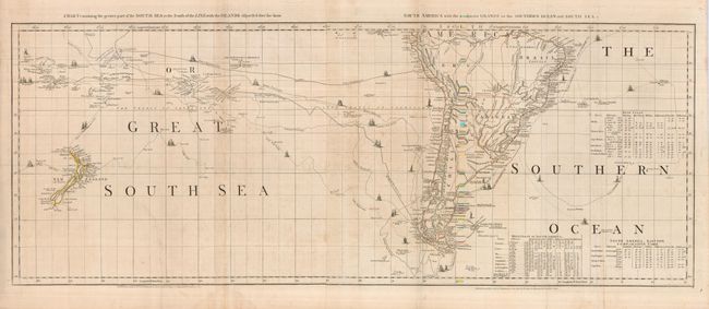
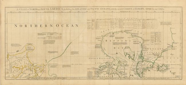
Subject: Western Hemisphere

Period: 1775 (dated)

Publication: American Atlas

Color: Hand Color

Size:
43.8 x 17 inches
111.3 x 43.2 cm
Download High Resolution Image
(or just click on image to launch the Zoom viewer)

This remarkable chart is the work of Braddock Mead, one of the most intriguing figures in British cartographic history as well as an extremely gifted mapmaker. Working under the alias John Green after serving time for defrauding an Irish heiress, he compiled many of Thomas Jefferys' most important maps. This chart records the tracks of the latest discoveries including numerous trans-Pacific voyages, Arctic explorations, and the Dutch voyages to the South Pacific. There are abundant commentaries throughout the maps, which is one of the characteristics of Mead's work. This edition includes several new voyages in the Pacific and alterations in the neighborhood of Bering's Strait including the insertion of the track of Lt. Sindo in 1764-67. Alaska appears as a large island named Alaschka within the large Northern Archipelago, and the coastline of North America is much more defined with several new place names including Mount St. Elias.

Consisting of six sheets (joined to form three large sheets, as issued) Size given is for each double sheet; the overall chart size would be 43.8 x 51" if joined. Each map is individually titled along the margins as follows:
Sheet I: Chart containing part of the Icy Sea with the adjacent Coast of Asia and America
Sheet 2: Chart comprising Greenland with the Countries and Islands about Baffin's and Hudson's Bays
Sheet 3: Chart containing the Coasts of California, New Albion, and Russian Discoveries to the North; with the Peninsula of Kamschatka, in Asia, opposite thereto; and Islands, dispersed over the Pacific Ocean, to the North of the Line
Sheet 4: North America and the West Indies with the opposite Coasts of Europe and Africa
Sheet 5: Chart containing the greater part of the South Sea to the South of the Line, with the Islands dispersed thro' the same
Sheet 6: South America with the adjacent Islands in the Southern Ocean and South Sea

References: Cumming (COL) pp.45-47; Phillips (M) p. 585; Stevens & Tree #4d.

Condition: B

Original outline color and full original margins. There is some minor foxing and a few mostly minor repairs in the blank margins. There is a closed 6" tear into the bottom left of the bottom sheet, entering a blank area of the <I>Great South Sea</I>. The tear is not obtrusive and is closed with reversible paper tape that could be easily replaced.

Estimate: $5,000 - $6,000

Sold for: $3,750

Closed on 9/24/2008

Archived