Catalog Archive
Auction 125, Lot 426

"A New and Correct Chart from England to Guinea with all the Tradeing part of the West Indies…", Thornton, John

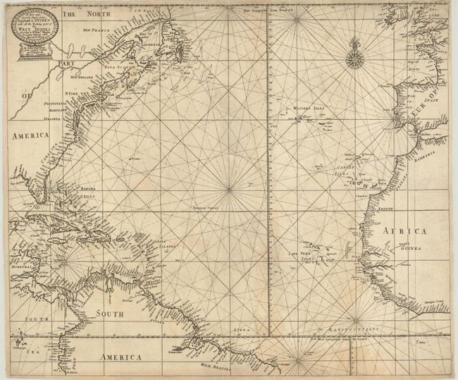
Subject: North Atlantic Ocean

Period: 1689 (circa)

Publication: A Sea Atlas (Atlas Maritimus)

Color: Black & White

Size:
22 x 18.5 inches
55.9 x 47 cm
Download High Resolution Image
(or just click on image to launch the Zoom viewer)

This scarce chart covers the North Atlantic and the surrounding coastlines including the Eastern Seaboard of North America, the West Indies, northern South America, West Africa, and Western Europe to Ireland. The title cartouche denounces Mercator's projection; showing a preference for the more popular Mr. Wright's projection, not as it is Vulgarly called Mercators Chart. A number of Thornton's charts of this period make this reference to Mr. Wright's projection. In North America, the distinct fishing banks off Newfoundland and the curious depiction of the St. Lawrence River stretching into the interior with tiny lakes in the Great Lakes region, are characteristics of Thornton's charts. John Thornton was one of the most important English mapmakers, from the so-called Thames School of chart makers, during the period when Britain dominated mapmaking. In addition to actual chart-making he also was a publisher. He was appointed Hydrographer to the Hudson Bay Company and the East India Company. This is the first state with John Thornton's imprint at the England, Scotland and Ireland in the Minories, London in the title cartouche.

References:

Condition: B+

Narrow, but adequate margins, as issued, with some edge tears repaired and backed with light Japanese tissue.

Estimate: $1,000 - $1,400

Sold for: $850

Closed on 9/24/2008

Archived