Catalog Archive
Auction 123, Lot 318

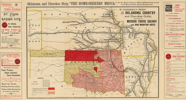
"A Correct Map of the Oklahoma Country and Cherokee Outlet, Reached via the Missouri Pacific Railway and Iron Mountain Route", Railroad Companies, (Various)

Subject: Oklahoma

Period: 1889 (dated)

Publication:

Color: Printed Color

Size:
20.8 x 14.5 inches
52.8 x 36.8 cm
Download High Resolution Image
(or just click on image to launch the Zoom viewer)

Attractive and brightly colored Oklahoma land rush promotional map. The map extends to include most of Arkansas and Missouri, portions of Nebraska, Colorado, Texas and all of Kansas. In the upper margin is a statement declaring the "Oklahoma and Cherokee Strip The Home-seekers Mecca". The map is color-keyed to show lands opened/not opened for settlement, and lands requiring a presidential declaration per the Peel Bill to be opened for settlement. The brochure states, "Now, when the Proclamation is issued, there will follow a scene that has never had a parallel of its kind in the history of this country. Sixteen counties and sixteen county sites will be settled up, as it were, in a single day, without conquest or strife." Folds into handsome yellow and red printed wrappers. A desirable issue.

References:

Condition: A

Very faint foxing in a couple blank areas. A very nice example.

Estimate: $200 - $250

Sold for: $350

Closed on 2/20/2008

Archived