Catalog Archive
Auction 122, Lot 902

"The Executive Documents, Thirtieth Congress, First Session. Volume 2. No. 8.", U.S. War Dept.

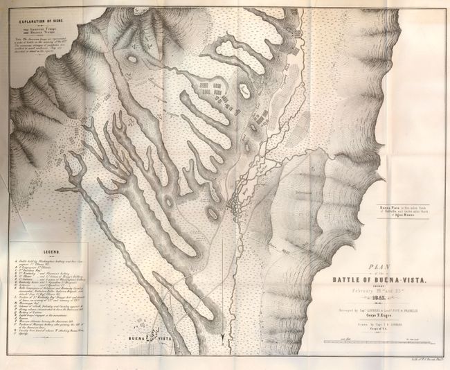
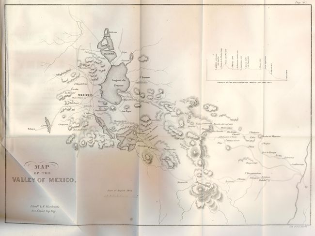
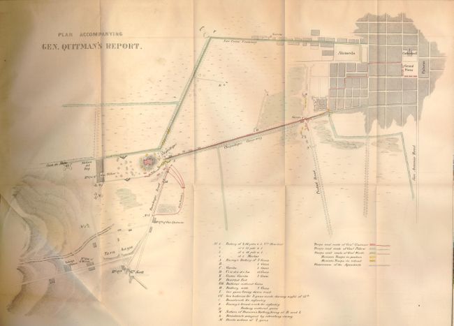
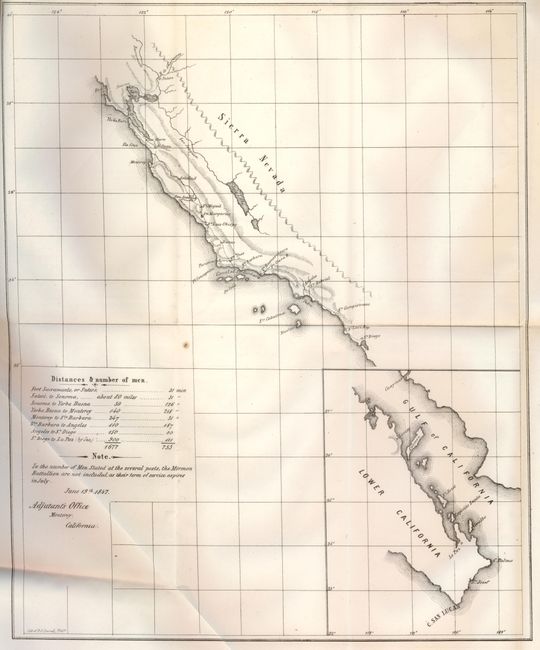
Subject: Mexican American War

Period: 1848 (published)

Publication:

Color: Black & White

Size:
6 x 9 inches
15.2 x 22.9 cm
Download High Resolution Image
(or just click on image to launch the Zoom viewer)

An important set of maps related to the Mexican American War. This index to the report, Message From the President of the United States to the Two Houses of Congress at the Commencement of the First Session of the Thirtieth Congress is an exhaustive collection of documents pertaining to the negotiation of peace between the United States and Mexico. Transcripts of official correspondence between the American Secretary of State, and eventual President, James Buchanan, and the Mexican Minister of Foreign Relations, Jose Monasterio, follow the President's opening remarks, and provide tremendous insight to the conflicting views of the neighboring republics, not to mention the formidable task of negotiating a peaceful solution to the hostilities. Included in this remarkable historical document are numerous tables, sketches, plans and eight foldout maps. The maps, plans and sketches of note are listed as follows:

Plan of the Battle of Buena Vista Fought February 22nd and 23rd 1847. Lithographic map drawn by Linnard and surveyed by Lieutenants Pope and Franklin. A very detailed plan showing a crucial battle in the war with Mexico. Outnumbered nearly 5 to 1, General Taylor's forces held, and finally defeated the advancing Mexican forces under General Santa Ana. A legend notes troop locations during the battle.
Survey of the Mexican Lines of Defence at Cerro Gordo... Surveyed by Major Turnbull and Capt. McLellan, illustrates one of the major battles of the Mexican American War. It shows mountains, roads, Mexican and American camps, gun batteries and the route of Shield's Brigade. Santa Ana had taken up a position at the pass of Cerro Gordo, thinking to halt Gen. Scott's advance on Mexico City. After fierce fighting, the Mexican forces were completely defeated, surrendering 3,000 prisoners (including 5 generals), over 4,000 stands of arms and 43 pieces of artillery. American losses were 64 killed and 353 wounded.
The Map of the Valley of Mexico is a plan of the vicinity around Mexico City. It includes the lakes and extends to include Toluca in the west, S. Antonio, Cholnla and Cuatlacingo in the east. Inset profile of the "Route between Mexico and Vera Cruz.
Battles of Mexico Line of Operation of the U.S. Army…General Winfield Scott. Large folding map, surveyed by Maj. Turnbull (with his signature in the plate), Capt. McClellan and Lt. Hardcastle, Corps of Topographical Engineers. Shows the position of Worth's Division outside of Churobusco and the Mexican forces north of the Churobusco River.
Map of Genl. Worth's Operations…. This plan details the action during the Battle of Churubusco, in the southeast portion of today's Mexico City and Mexico's center of the television and movie industry. Worth was second in command to General Zachary Taylor at the outbreak of the Mexican War. Very detailed showing individual buildings and locations of the combatants. Surveyed by Capt. Mason and Lieut. Hardcastle.
Battles of Mexico Line of Operation of the U.S. Army…General Winfield Scott on the 8th, 12th and 13th of September, 1847Large folding map, surveyed by Maj. Turnbull (with his signature in the plate), Capt. McClellan and Lt. Hardcastle, Corps of Topographical Engineers. Shows the position of American forces outside of Molino De Rey and Chapultepec with the Mexican forces between Molino Del Rey and Mexico City. Very detailed on the roads, churches, haciendas, etc.
Plan Accompanying Gen. Quitman's Report. This map shows the headquarters and positions of the American forces, south of Chepultepec, batteries, weaponry etc. But most interestingly it depicts, by hand coloring, the positions of Mexican troops and the route of the American forces during the assault on Mexico City.

8vo. Complete. Rebound in blue cloth covered boards with white printed title on spine. 1369 pp. plus a 249 page Appendix titled "Report of the Secretary of War. In Answer to a Resolution of the Senate. Calling for Such Military Reports As Have Been Received From the Commanders of Our Army in Mexico, Since the Transmission of the Annual Report of the Secretary of War. January 4th, 1848."

References:

Condition: A

Maps generally very good. Most have some light toning along folds and minor fold separations, but are still bright and nicely engraved. Contents have some light foxing and minimal spots. Covers, spine and binding as new. A library stamp from Smith College is inside front cover. A letter from the school's Director of Libraries acknowledges proper withdrawal.

Estimate: $800 - $1,000

Unsold

Closed on 12/5/2007

Archived