Catalog Archive
Auction 122, Lot 894

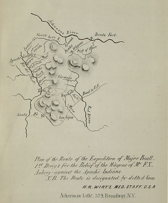
"California and New Mexico", U.S. Government

Subject: Exploration and Surveys, California and New Mexico

Period: 1850 (dated)

Publication: Ex. Doc. No. 17.

Color: Black & White

Size:
5.8 x 9 inches
14.7 x 22.9 cm
Download High Resolution Image
(or just click on image to launch the Zoom viewer)

This interesting report contains five (of seven) maps including an attractive Map of Fort Hill Monterey California… that locates several private claims and the Monterey Redoubt. The map has a scale of eight inches to the mile, and shows the variation between the magnetic and true meridians. A simple border and fancy vignette of an eagle, U.S. flag and weaponry are also featured on this example. Other maps include Sketch of Port Escondido Lower California, and an untitled map of California that locates Sausalito, Yerba Buena and a large Presidio. 8vo. 976 pp. Bound in original marbled boards with quarter leather spine and tips. Gilt title on spine.

References:

Condition: B

The maps have just a touch of toning and one with a little light offsetting. Textual pages with some occasional foxing. The first 10 signartures are together but mostly loose from the binding. A couple of loose pages. Covers and spine are scuffed and shelf worn. Front cover and endpaper are separated. Spine is cracked vertically in a couple places. Will benefit from the attentions of a book binder.

Estimate: $100 - $150

Sold for: $120

Closed on 12/5/2007

Archived