Catalog Archive
Auction 121, Lot 68

"A New & Exact Map of the Coast, Countries and Islands within ye Limits of ye South Sea Company…", Moll, Herman

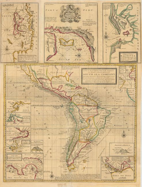
Subject: Western Hemisphere , South America

Period: 1711 (circa)

Publication:

Color: Hand Color

Size:
19.3 x 26 inches
49 x 66 cm
Download High Resolution Image
(or just click on image to launch the Zoom viewer)

A fascinating and uncommon map of South America, includes the southern portion of North America with the island of California and Central America. The sheet also has twelve smaller inset maps, including Isle Chiloe, Acapulco, the Gallapagos Islands, the Isthmus of Darien, Straits of Magellan, Juan Fernando, the Gulf of Nicoya, the Gulf of Fonseca, Port Baldivia (Valdivia), the sea route from England to the Orinoco, the Bay of Guayaquil, and, interestingly, an inset of the phantom Pepys Island. Pepys Island was named for Samuel Pepys by Ambrose Cowley in 1684, who placed it a couple hundred miles north of the Falkland Islands. Many expeditions attempted to locate the island, and it is assumed it was a misplaced member of the Falkland Islands. The top three insets are printed separately and joined to the main map, indicating this is the second state per McLaughlin. The map is filled with indications of currents, tradewinds and compass roses. The decorative cartouche in the map of Guayaquil contains a dedication to Robert, Earl of Oxford.

References: McLaughlin #181.

Condition: B

A sharp impression with original outline color. The map has folds as issued, with a couple of minor repaired separations. There are a couple of light stains. The top and bottom margins each have a repaired tear that just comes past the neatline. Margins trimmed, but still sufficient for framing.

Estimate: $900 - $1,200

Sold for: $650

Closed on 9/26/2007

Archived