Catalog Archive
Auction 119, Lot 83

"L'Amerique autrement le Nouveau Monde et Indes Occidentales…", Duval, Pierre

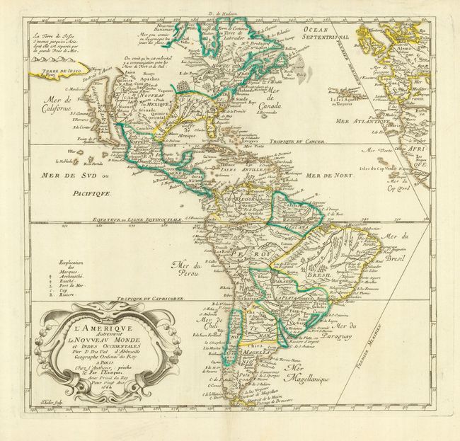
Subject: Western Hemisphere

Period: 1664 (dated)

Publication: Carte de Geographie les plus Nouvelles…

Color: Hand Color

Size:
15 x 14.5 inches
38.1 x 36.8 cm
Download High Resolution Image
(or just click on image to launch the Zoom viewer)

This is an uncommon map of the Americas based largely on the cartography of Nicolas Sanson, Duval's uncle. In North America, the Great Lakes are shown open-ended in the west and California is depicted as an island. Above California is the Destroit d' Anien and the large Terre de Iesso, or land of Jesso, that was the result of confusing reports by De Vries on his expedition in the waters north of Japan. Several colonial settlements appear on the eastern seaboard including Iamestoun, Christina, London al: Boston, N. Amsterdam al: Manhate. In South America, the mythical Parime Lake is located in Guiana with its legendary Manoa-el dorado (City of Gold). There is good detail of the missions. The map includes the western coasts of Europe and Africa and the Prime Meridian goes through the Isle de Fer. The map was originally engraved in 1655 and appeared in several states until Duval's death in1683.

References: Burden #311, state 4; McLaughlin #15, state 3.

Condition: A

Nice impression with original outline color and wide original margins. Minor repairs in blank margins, well away from map.

Estimate: $1,500 - $2,000

Unsold

Closed on 5/9/2007

Archived