Catalog Archive
Auction 118, Lot 852

"Africae, described the manners of their habits, and buildings…", Speed, John
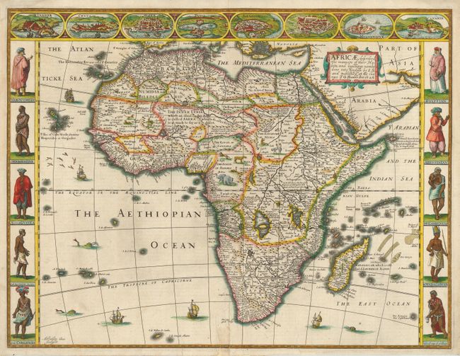
Subject: Africa

Period: 1626 (dated)

Publication: Prospect of the World

Color: Hand Color

Size:
20.3 x 15.5 inches
51.6 x 39.4 cm
Download High Resolution Image
(or just click on image to launch the Zoom viewer)

This decorative map is the first map of Africa prepared by an English cartographer. It presents a typical, early seventeenth century view of the continent with the interior filled with fictitious mountains, rivers and lakes. The origin of the Nile conforms to the Ptolemaic tradition of the large twin lakes in the southern part of the continent. The kingdom of Monomotapa occupies a large region in southern Africa. There are numerous interesting notations, including several concerning where gold can be found. The English text on verso provides a facinating view of the European concept concerning the wildlife and customs and manners of the African people. There is a description of Anthropophagi, cannibals, who kill their own babies to avoid the trouble of raising them; but, in order to preserve their race, steal children from their neighbors. The beautiful carte-a-figures border features natives in their tribal costume. At top is a panel of panoramas and plans illustrating Tanger, Ceuta, Alger, Tunis, Alexandria, Cairo (Alca), Mozambique and the Canaries. Finely engraved by Abraham Goos, with his signature at lower left.

References: Norwich #30; Tooley (AF) pp.113-14.

Condition: B

Professional repairs on some tears at bottom, one extending 2" into map.

Estimate: $3,500 - $4,000

Sold for: $6,000

Closed on 3/6/2007

Archived