Catalog Archive
Auction 118, Lot 427

"Regni Mexicani seu Novae Hispaniae, Ludovicianae, N. Angliae, Carolinae, Virginiae, et Pensylvaniae nec non Insularum Archipelagi Mexicani in America Septentrionali Accurata Tabula …", Homann, Johann Baptist

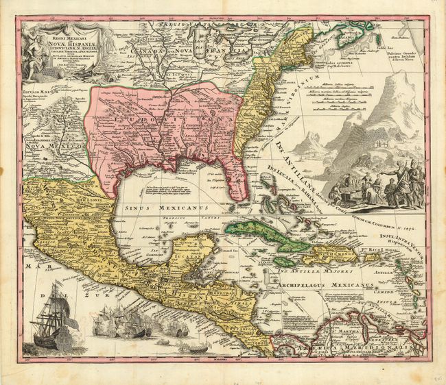
Subject: Colonial United States, Mexico & Caribbean

Period: 1712 (circa)

Publication:

Color: Hand Color

Size:
22 x 18.5 inches
55.9 x 47 cm
Download High Resolution Image
(or just click on image to launch the Zoom viewer)

A superb map covering the region from the Great Lakes and Nova Scotia through Central America, the Caribbean and Venezuela, and from New Mexico to the eastern seaboard. The map is based largely on Delisle's map of 1703 (Carte du Mexique et de la Floride). The British colonies are shown confined east of the Appalachians. The map itself is filled with settlement place names, Indian tribes and villages. Sea routes from Vera Cruz and Cartagena to Havana and Spain are outlined. It is richly embellished with a fine title cartouche depicting two native figures and symbols of America's natural resources. In the Atlantic is a large engraved scene of extensive gold mining operations with Indians bringing their treasures to fill the European's chest. Off the Pacific coast of Mexico is yet another opulent engraving of a raging sea battle between many ships.

References: Van Ermen p.42; cf Cumming (SE) #137; Manasek #72; Martin & Martin plt.17.

Condition: B

Very good impression and original color. Some light, scattered stains and a small hole in the upper, blank margin, else very good.

Estimate: $1,500 - $2,000

Sold for: $2,000

Closed on 3/6/2007

Archived