Catalog Archive
Auction 118, Lot 300

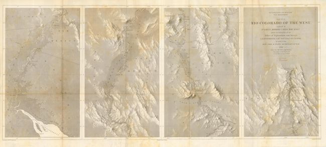
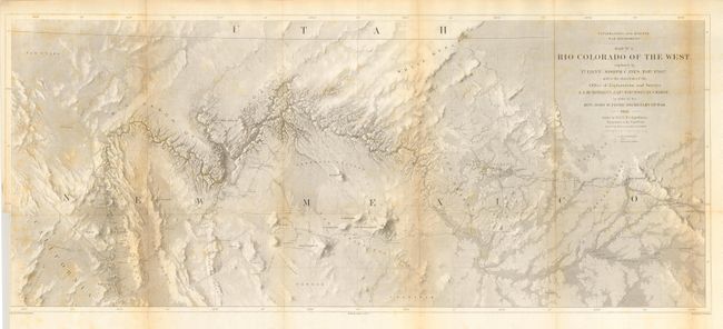
"[Lot of 2] Map No. 1 [and] Map No. 2 Rio Colorado of the West", Ives, Joseph C. (Lt.)

Subject: United States - Southwestern

Period: 1861 (published)

Publication: Report upon the Colorado River of the West

Color: Black & White

Size:
34 x 14 inches
86.4 x 35.6 cm
Download High Resolution Image
(or just click on image to launch the Zoom viewer)

This pair of maps represents one of the most important exploring efforts of the American Southwest. Ives published his explorations in a series of four maps, these being the first two. In his book Mapping of the Trans-Mississippi West, Carl Wheat devotes several pages to these two maps saying they are two of the best created by the remarkable F.W. von Egloffstein. They were engraved using his system that imparts the appearance of depth to the topography and nearly mimics a satellite image. A remarkable accomplishment for the time. Each map measures the approximate size given.
The first map shows the topography and geology of the lower Colorado River in four panels (each about 8.5" x 14"), beginning at the Gulf and ending in Black Canon at Fortification Rock. Locates and names Pt. Invincible, Ogden's Landing, Fort Yuma, Lighthouse Rock, The Needles, the location of Beale's Crossing, Bullshead (today's Bullhead City), Painted Canon, Fortification Rock, and much more. Numerous rapids are noted including Roaring Rapid, 3 large rocks & one sunken rock below, and Violent Rapid with rocks on both sides.
The second map details the region around the Grand Canyon and Little Colorado River. It shows the river from about Needles (Whipple's Crossing and Mojave Canyon) north through Black Canyon, to the Little Colorado and then north to beyond the survey's limit as the riverbed fades to nothing. The map locates Fort Defiance, Campbell's Pass, Zuni, Moquis (Hopi) Pueblos, San Francisco Springs (Flagstaff), Las Vegas, the Mormon Road, numerous Indian tribes, and much more. Several important exploration routes & trails are shown including The Old Spanish Trail, Whipple's trail 1854-4 and Beale's trail.

References: Wheat (TMW) #947 & #948.

Condition: B

Both folding as issued. Scattered foxing on both. The first has a short tear at binding trim that just enters the map, closed on verso. The latter has binding trim at lower left just into border, as issued.

Estimate: $250 - $300

Sold for: $220

Closed on 3/6/2007

Archived