Catalog Archive
Auction 117, Lot 7

"[Untitled - World]", Bordone, Benedetto
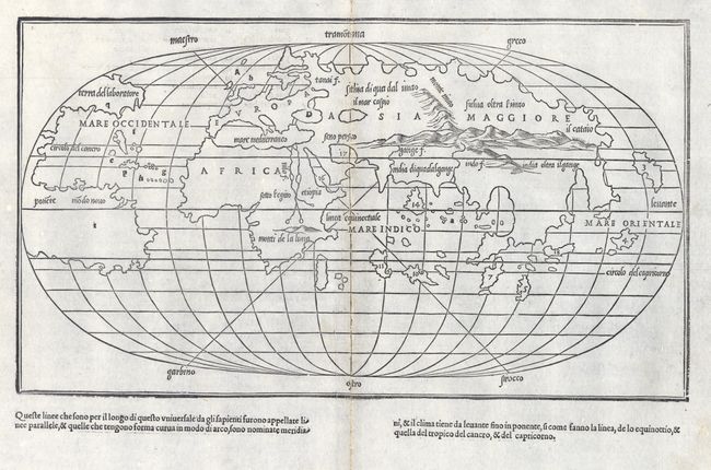
Subject: World

Period: 1528 (circa)

Publication: Libro di Benedetto Bordone … de tutte l'Isole de mondo…

Color: Black & White

Size:
15 x 8.5 inches
38.1 x 21.6 cm
Download High Resolution Image
(or just click on image to launch the Zoom viewer)

This is one of the earliest world maps drawn on an oval projection, preceded only by that of Francesco Rosselli's map of circa 1508. Bordone's map presents the world in a simple outline; its purpose being that of an index map for his Isolario (island book). Underlining the map is a system of parallels and meridians with lines criss-crossing the map representing the six wind directions, which are named in the margins. It reflects the most recent discoveries, such as the connection between North and South America and the separation of North America from Asia. South America still retains its truncated shape, the extremity of which is about 30° south latitude. There is still a remnant of the Ptolemaic land-bridge between Africa and Southeast Asia, shown as a string of large islands. But, Bordone has eliminated the Antarctic landmass shown on Rosselli's map. North America bears the inscription Terra del laboratore and South America is labeled Modo Novo. The other names on the map are in a graceful italic script with numerals referring to the island maps indexed here.

Bordone was an illuminator and wood-engraver, working in Venice, when he was given permission by the Senate in 1508 to print maps of Italy and the world. None of those maps have survived and his only remaining works are the maps from this Isolario.

References: Moreland & Bannister p.14; Nordenskiold (Facsimile) p. 90 & 104, plt. 39; Shirley #59.

Condition: B

Good impression. Bit of worming along centerfold with slight loss, professionally infilled and reinforced with light Japanese tissue. Otherwise very fine.

Estimate: $4,000 - $5,000

Sold for: $3,000

Closed on 12/6/2006

Archived