Catalog Archive
Auction 117, Lot 122

"A Particular Map, to Illustrate Gen. Amherst's Expedition, to Montreal; with a Plan of the Town & Draught of ye Island", Gibson, John

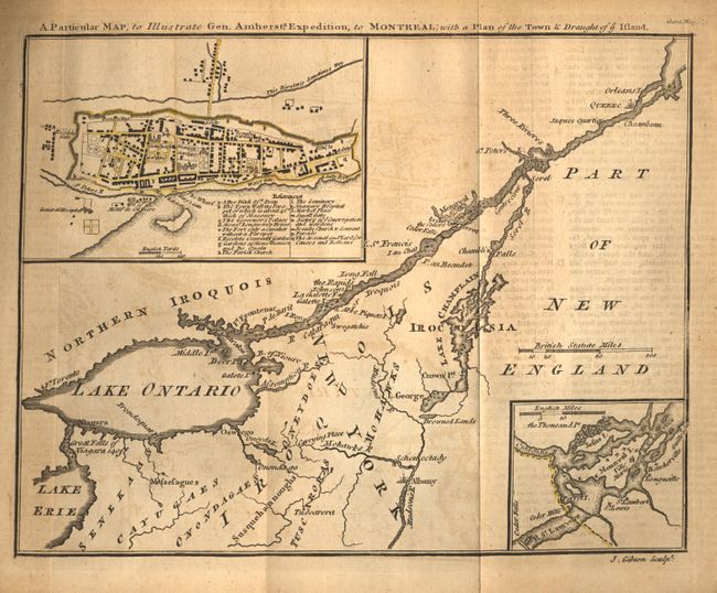
Subject: Colonial United States and Canada

Period: 1760 (published)

Publication: Gentleman's Magazine

Color: Black & White

Size:
9 x 7 inches
22.9 x 17.8 cm
Download High Resolution Image
(or just click on image to launch the Zoom viewer)

After the fall of Quebec, Montreal was the sole remaining French power center in Canada. The British General, Jeffery Amherst, occupied Fort Ticonderoga and Crown Point in the fall of 1759. He began a three-pronged offensive converging on Montreal the following spring. When Vaudreuil de Cavagnal surrendered on September 8, 1760, this ended the last major campaign of the French and Indian War. This map shows the St. Lawrence River from Quebec City to the Great Falls of Niagara 140ft and over to include the Hudson River, Albany and Lake Champlain. Details include several forts, Drowned Lands, and Indian tribes. Insets of the environs of Montreal Island and a plan of the walled city of Montreal are included. The folding map is still bound into the October 1760 issue with an account of General Amherst's expedition.

References: Jolly GENT-145.

Condition: B

Text and map are lightly toned with minor offsetting. The map is uncolored and the insets both have yellow outline color. Minor fold separations in top margin. Couple of torn corners in text.

Estimate: $170 - $200

Sold for: $160

Closed on 12/6/2006

Archived