Catalog Archive
Auction 115, Lot 300

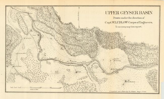
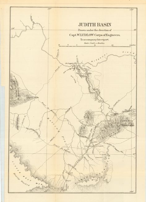
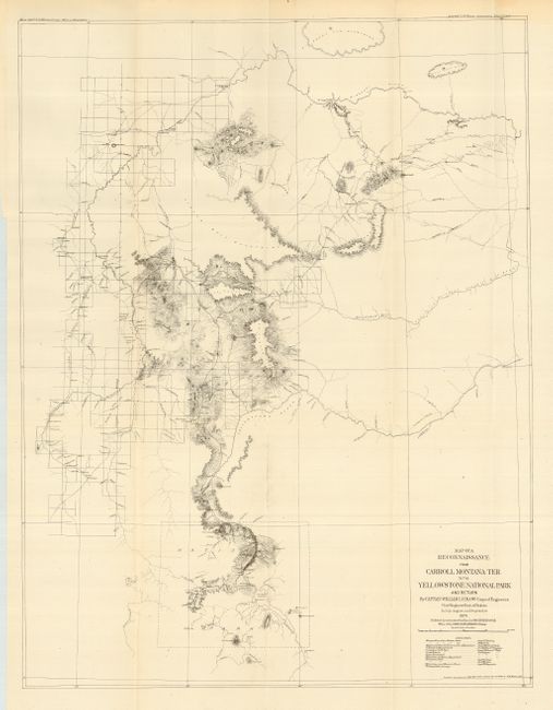
"[Lot of 3 - Yellowstone]", Ludlow, William (Capt.)

Subject: Wyoming - Yellowstone

Period: 1875 (dated)

Publication: Reconnaissance From Carroll Montana Territory...To The Yellowstone National Park

Color: Black & White

Size:
See Description
Download High Resolution Image
(or just click on image to launch the Zoom viewer)

Carl Wheat hypothesizes that Capt. William Ludlow (1843 - 1901), Corps of Engineers, was assigned the task of surveying the road from Carroll, Montana on the Missouri to Fort Ellis near Bozeman as a reward for good service, since it allowed him to inspect the wonders of Yellowstone without a furlough. These three maps were produced to accompany Ludlow's official report. In his report, Ludlow says "My own interest in this land of wonder is so keen as to lead me again to hope that it will be protected from the vandalism which it has already suffered, and that the suggestion of an accurate topographical and geological survey, to complete the work so well inaugurated by Professor Hayden, may be made the subject of favorable consideration and recommendation by the Chief of Engineers."

The first map, "A Map of a Reconnaissance from Carroll Montana Ter. to the Yellowstone National Park and Return" describes the newly opened Carroll Road. The road cut more than 200 miles from the previous route between Helena and Corinne. This resulted in a savings of about fifteen days considering the 12 or 13 miles per day the heavy bull-trains averaged. The map shows a large area from the Missouri River in the north to Helena in the west and the newly established National Park in the south. The flow of the Yellowstone, Musselshell, and Missouri Rivers are designated. It has a partial look to it; the Topographical Engineers were rigorous about showing only features they had actually surveyed. Land forms are shown with what appears to be contour lines but there is no interval stated, and Wheat calls it a pseudo-contour map. Carroll was washed away by a flood in the 1880’s and no trace of it remains today. Ironically, it is not named on the map itself. (18.8 x 24.8")

The second map "Upper Geyser Basin" gives a detailed look at the Firehole River, hot pools, and geysers around the Old Faithful Geyser Basin. Names Bath Tub, Giantess, Bee Hive, Castle, Saw Mill, Grand, Giant, Grotto, Riverside, Fan, Pyramid, Punch Bowl, and Black Sand. (15.3 x 8.8")

The third map is "Judith Basin" [Montana] which details the region from the Missouri River to the Little Belt Mountains. Camp Lewis is seen as a crossroads, with the Trail to Benton going to the northwest. To the south is the Trail to Shaw running roughly parallel to the first. (11.8 x 17.2")

References: Wheat (TMW) 1257, 1258 & 1259

Condition: A

Very nice condition with only a few tiny fold intersection splits, short binding trim tear on #3 closed on verso with archival tape.

Estimate: $250 - $300

Sold for: $180

Closed on 6/21/2006

Archived