Catalog Archive
Auction 115, Lot 245

"Map of Chicago River Accompanying the Annual Report of Tho. Jefferson Cram Capt. U. S. T. E. Sep. 1839", Cram, Thomas Jefferson (Capt.)

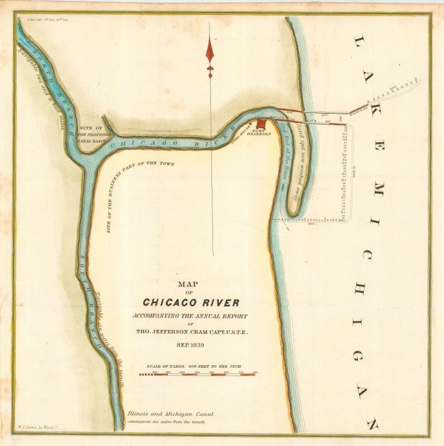
Subject: Illinois, Chicago

Period: 1839 (dated)

Publication: Senate Doc. #140, 1st Sess. 26th Congress

Color: Hand Color

Size:
11 x 11 inches
27.9 x 27.9 cm
Download High Resolution Image
(or just click on image to launch the Zoom viewer)

This is one of the earliest printed maps to focus on the vicinity of Chicago, which at this time was home to less than 200 people. It shows the Chicago River and a sand spit jutting into Lake Michigan noted as "now washed away." Fort Dearborn, a light house and the "Site of the Business Part of the Town" are located. Engraved by W.J. Stone. Thomas Jefferson Cram (1807-1883) graduated from West Point in 1826. He served as a mathematics instructor at the Academy until 1838, when he joined the U.S. Army Topographical Engineers and was assigned to the Great Lakes harbor surveys. In 1855 he became Chief of the Topographical Engineers, Western Division. He served with distinction in the Civil War and reached the rank of Brevet-General. After the war General Cram was Chief of Engineers, Great Lakes Harbor Improvements.

References: Claussen & Friis #332.

Condition: B

Bit of light foxing. Paper added to binding trim to better accommodate framing.

Estimate: $250 - $300

Sold for: $650

Closed on 6/21/2006

Archived