Catalog Archive
Auction 115, Lot 13

"Orbis Terrarum Typus de Integro in Plurimis Emendatus, Auctus, et Icunculis Illustratus", Visscher, Nicolas
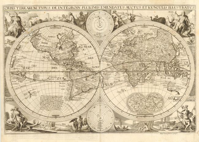
Subject: World

Period: 1660 (circa)

Publication:

Color: Black & White

Size:
18.3 x 12.3 inches
46.5 x 31.2 cm
Download High Resolution Image
(or just click on image to launch the Zoom viewer)

This map is a direct derivative of Nicolas Visscher's first world map designed for inclusion in Dutch Bibles. It has been re-engraved, is nominally larger, and this example is from a German Bible. Identical engravings, including allegorical representations of the continents as well as native inhabitants and wildlife, surround the double hemisphere world map. Two celestial spheres are displayed in the Eastern Hemisphere. In the lower part of the Western Hemisphere is text describing the discovery of America and recent voyages of discovery. Two diagrams depicting the Ptolemaic and Copernican theories of the solar system are tucked between the hemispheres. The northwest coast of North America is exaggerated and shows California correctly as a peninsula. Parts of Australia and Van Diemen's Land are shown but the north coast of Australia is not depicted. This map now shows the western coastline of New Zealand reflecting Tasman's discovery in 1642. German text on verso. Shirley notes several derivatives in his Corrigenda and Addenda (2001 revised edition of The Mapping of the World). This most closely matches #414A, although there is no additional outer scroll border.

References: Shirley #414.

Condition: B

Full original margins. Light soil and a couple of unobtrusive spots of candle wax.

Estimate: $2,200 - $2,400

Sold for: $1,700

Closed on 6/21/2006

Archived