Catalog Archive
Auction 114, Lot 370

"A New Royal Geographical Pastime for England and Wales Whereby The Distance of each Town is Laid Down from London in Measured Miles Being a very amusing Game to Play with a Teetotum, Ivory Pillars and Counters", Laurie & Whittle

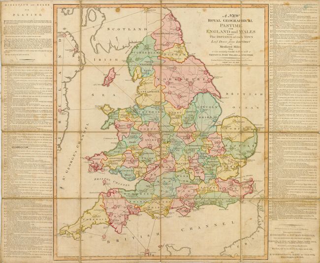
Subject: England & Wales - Board Game

Period: 1794 (dated)

Publication:

Color: Hand Color

Size:
26 x 21.5 inches
66 x 54.6 cm
Download High Resolution Image
(or just click on image to launch the Zoom viewer)

This is a very early board game where the players move about England and Wales based on the rules at upper left. Basically, the players (2 to 6) spin the 'totum' and move their 'pillar' the indicated number of moves. Each pillar has four counters of the same color that represent servants who perform tasks such as waiting for your next turn. The game has 169 place names listed in the side columns. Each place is moved through in order as the game progresses. Quaint information is given for each of the 169 stops along the way: "Dunmow, where a slice of bacon is given to every married couple that are happy and not repented their bargain, for which you pay 2 counters." The winner is the first player to reach London, "which crowns the utmost of the player's desires, and wins the stakes with the Game." Does not include the pieces (pillars, totum, or counters) which are sadly missing. At lower left are advertisements for the publisher's similar game based on Europe, and "A Collection of New Maps Dissected…" A remarkable and very early 'board' game that comprises a hand colored copper engraved map segmented on original linen.

References:

Condition: B

Dark impression and original full hand coloring. Light occasional toning or foxing, else very good.

Estimate: $600 - $800

Sold for: $250

Closed on 3/1/2006

Archived