Catalog Archive
Auction 114, Lot 274

"Map of a Reconnaissance of the Black Hills, July and August, 1874, with troops under the command of Lt. Col. G. A. Custer, 7th Cavalry. By Capt. Wm. Ludlow, Corps of Engineers.", U.S. War Department

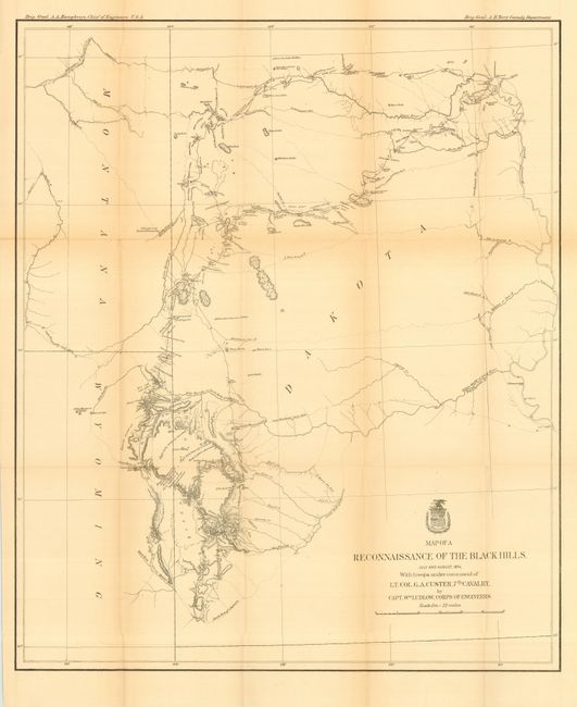
Subject: South Dakota

Period: 1874 (dated)

Publication: Report of a Reconnaissance of the Black Hills of Dakota

Color: Black & White

Size:
21 x 25.5 inches
53.3 x 64.8 cm
Download High Resolution Image
(or just click on image to launch the Zoom viewer)

This is Ludlow's principle map that shows the entirety of Custer's reconnaissance of 1874. The map extends from Old Ft. Pierre on the Missouri River to the Little Missouri Buttes and north to the Badlands and the Yellowstone River. In the summer of 1874, Custer took units of his 7th Cavalry and 2nd Infantry Companies on a now famous march from Ft. A. Lincoln into the Black Hills of the Dakotas. On this expedition, gold was discovered. Word of the discovery led to the Black Hills Gold Rush, then to Custer's massacre and eventually to the tragic end of the Sioux War at Wounded Knee. This map traces Custer's route through the region of the Black Hills with the date of each encampment. The map contains many interesting notations, such as "Where they killed the Rees," "Where the sickman was killed" plus many comments on water, grasslands, springs, etc. The topography is nicely developed and portions of Raynold's 1859 route is shown.

References: Wheat (TMW) #1248.

Condition: B

Folding, as issued. A little light toning along two folds, some tiny fold intersection splits, else very good.

Estimate: $300 - $400

Sold for: $250

Closed on 3/1/2006

Archived